You are here: Home > Network List > ZJ12 - Transantarctic Mountains Northern Network Stations List
> Station DUBY Mt Kring, Antarctica > Earthquake Result Viewer
DUBY Mt Kring, Antarctica - Earthquake Result Viewer
| Earthquake location: |
Vanuatu Islands |
| Earthquake latitude/longitude: |
-17.0/168.5 |
| Earthquake time(UTC): |
2015/01/23 (023) 03:47:27 GMT |
| Earthquake Depth: |
218 km |
| Earthquake Magnitude: |
6.8 MWP, 6.9 MI, 7.0 MI |
| Earthquake Catalog/Contributor: |
NEIC PDE/NEIC COMCAT |
|
| Network: |
ZJ Transantarctic Mountains Northern Network |
| Station: |
DUBY Mt Kring, Antarctica |
| Lat/Lon: |
74.99 S/158.08 E |
| Elevation: |
1508 m |
|
| Distance: |
58.3 deg |
| Az: |
183.188 deg |
| Baz: |
11.778 deg |
| Ray Param: |
0.06222403 |
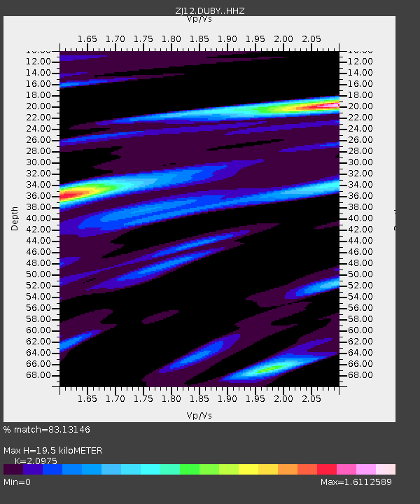
| Estimated Moho Depth: |
19.5 km |
| Estimated Crust Vp/Vs: |
2.10 |
| Assumed Crust Vp: |
6.182 km/s |
| Estimated Crust Vs: |
2.947 km/s |
| Estimated Crust Poisson's Ratio: |
0.35 |
|
| Radial Match: |
83.13146 % |
| Radial Bump: |
346 |
| Transverse Match: |
65.28379 % |
| Transverse Bump: |
400 |
| SOD ConfigId: |
3390531 |
| Insert Time: |
2019-04-16 03:46:43.746 +0000 |
| GWidth: |
2.5 |
| Max Bumps: |
400 |
| Tol: |
0.001 |
|

Signal To Noise
| Channel | StoN | STA | LTA |
| ZJ:DUBY: :HHZ:20150123T03:56:27.419019Z | 7.8651943 | 2.810803E-6 | 3.5737236E-7 |
| ZJ:DUBY: :HHN:20150123T03:56:27.419019Z | 4.595901 | 1.1292385E-6 | 2.457056E-7 |
| ZJ:DUBY: :HHE:20150123T03:56:27.419019Z | 1.3414534 | 4.1800254E-7 | 3.116042E-7 |
| Arrivals |
| Ps | 3.6 SECOND |
| PpPs | 9.4 SECOND |
| PsPs/PpSs | 13 SECOND |


