You are here: Home > Network List > TA - USArray Transportable Network (new EarthScope stations) Stations List
> Station W41B Gary Mavity, Velonia, AR, USA > Earthquake Result Viewer
W41B Gary Mavity, Velonia, AR, USA - Earthquake Result Viewer
| Earthquake location: |
Near Coast Of Northern Chile |
| Earthquake latitude/longitude: |
-19.8/-70.9 |
| Earthquake time(UTC): |
2014/03/22 (081) 12:59:59 GMT |
| Earthquake Depth: |
20 km |
| Earthquake Magnitude: |
6.2 MWW, 6.2 MWB, 6.3 MWC, 6.4 MWC |
| Earthquake Catalog/Contributor: |
NEIC PDE/NEIC COMCAT |
|
| Network: |
TA USArray Transportable Network (new EarthScope stations) |
| Station: |
W41B Gary Mavity, Velonia, AR, USA |
| Lat/Lon: |
35.17 N/92.25 W |
| Elevation: |
95 m |
|
| Distance: |
58.3 deg |
| Az: |
339.452 deg |
| Baz: |
156.202 deg |
| Ray Param: |
0.06292334 |
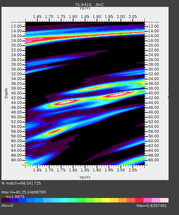
| Estimated Moho Depth: |
40.25 km |
| Estimated Crust Vp/Vs: |
1.99 |
| Assumed Crust Vp: |
6.498 km/s |
| Estimated Crust Vs: |
3.269 km/s |
| Estimated Crust Poisson's Ratio: |
0.33 |
|
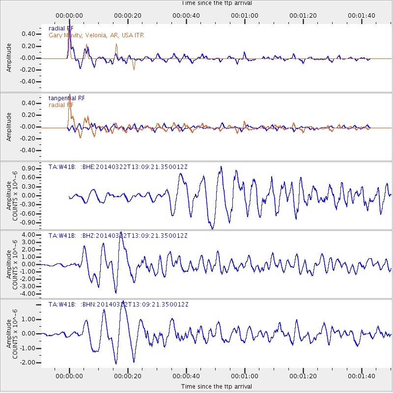
| Radial Match: |
96.041725 % |
| Radial Bump: |
368 |
| Transverse Match: |
78.60305 % |
| Transverse Bump: |
400 |
| SOD ConfigId: |
626651 |
| Insert Time: |
2014-04-21 10:44:40.201 +0000 |
| GWidth: |
2.5 |
| Max Bumps: |
400 |
| Tol: |
0.001 |
|
Signal To Noise
| Channel | StoN | STA | LTA |
| TA:W41B: :BHZ:20140322T13:09:21.350012Z | 3.9297755 | 5.0709343E-7 | 1.2903878E-7 |
| TA:W41B: :BHN:20140322T13:09:21.350012Z | 1.8024352 | 1.3221482E-7 | 7.335344E-8 |
| TA:W41B: :BHE:20140322T13:09:21.350012Z | 1.298072 | 1.3927406E-7 | 1.0729302E-7 |
| Arrivals |
| Ps | 6.4 SECOND |
| PpPs | 18 SECOND |
| PsPs/PpSs | 24 SECOND |


