You are here: Home > Network List > ZJ12 - Transantarctic Mountains Northern Network Stations List
> Station SHRD Lister Nunataks, Antarctica > Earthquake Result Viewer
SHRD Lister Nunataks, Antarctica - Earthquake Result Viewer
| Earthquake location: |
Vanuatu Islands |
| Earthquake latitude/longitude: |
-17.0/168.5 |
| Earthquake time(UTC): |
2015/01/23 (023) 03:47:27 GMT |
| Earthquake Depth: |
218 km |
| Earthquake Magnitude: |
6.8 MWP, 6.9 MI, 7.0 MI |
| Earthquake Catalog/Contributor: |
NEIC PDE/NEIC COMCAT |
|
| Network: |
ZJ Transantarctic Mountains Northern Network |
| Station: |
SHRD Lister Nunataks, Antarctica |
| Lat/Lon: |
73.40 S/160.50 E |
| Elevation: |
2457 m |
|
| Distance: |
56.6 deg |
| Az: |
182.758 deg |
| Baz: |
9.218 deg |
| Ray Param: |
0.06331034 |
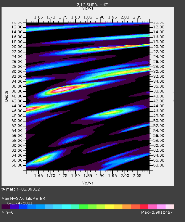
| Estimated Moho Depth: |
37.0 km |
| Estimated Crust Vp/Vs: |
1.75 |
| Assumed Crust Vp: |
6.264 km/s |
| Estimated Crust Vs: |
3.585 km/s |
| Estimated Crust Poisson's Ratio: |
0.26 |
|
| Radial Match: |
85.09032 % |
| Radial Bump: |
387 |
| Transverse Match: |
74.59418 % |
| Transverse Bump: |
400 |
| SOD ConfigId: |
3390531 |
| Insert Time: |
2019-04-16 03:46:50.194 +0000 |
| GWidth: |
2.5 |
| Max Bumps: |
400 |
| Tol: |
0.001 |
|

Signal To Noise
| Channel | StoN | STA | LTA |
| ZJ:SHRD: :HHZ:20150123T03:56:15.659985Z | 3.8083797 | 1.1393332E-6 | 2.9916484E-7 |
| ZJ:SHRD: :HHN:20150123T03:56:15.659985Z | 1.8141781 | 5.7046265E-7 | 3.1444688E-7 |
| ZJ:SHRD: :HHE:20150123T03:56:15.659985Z | 1.8078119 | 3.8341707E-7 | 2.1208903E-7 |
| Arrivals |
| Ps | 4.6 SECOND |
| PpPs | 15 SECOND |
| PsPs/PpSs | 20 SECOND |


