You are here: Home > Network List > IU - Global Seismograph Network (GSN - IRIS/USGS) Stations List
> Station PMG Port Moresby, New Guinea > Earthquake Result Viewer
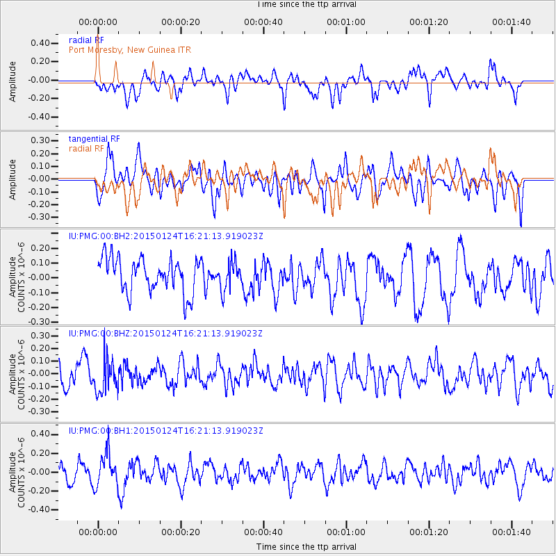
PMG Port Moresby, New Guinea - Earthquake Result Viewer
*The percent match for this event was below the threshold and hence no stack was calculated.
| Earthquake location: |
Myanmar-India Border Region |
| Earthquake latitude/longitude: |
25.0/95.1 |
| Earthquake time(UTC): |
2015/01/24 (024) 16:11:41 GMT |
| Earthquake Depth: |
110 km |
| Earthquake Magnitude: |
4.8 MW, 4.5 mb |
| Earthquake Catalog/Contributor: |
ISC/ISC |
|
| Network: |
IU Global Seismograph Network (GSN - IRIS/USGS) |
| Station: |
PMG Port Moresby, New Guinea |
| Lat/Lon: |
9.40 S/147.16 E |
| Elevation: |
90 m |
|
| Distance: |
61.2 deg |
| Az: |
117.315 deg |
| Baz: |
305.211 deg |
| Ray Param: |
$rayparam |
*The percent match for this event was below the threshold and hence was not used in the summary stack. |
|
| Radial Match: |
54.33122 % |
| Radial Bump: |
400 |
| Transverse Match: |
59.064754 % |
| Transverse Bump: |
400 |
| SOD ConfigId: |
3390531 |
| Insert Time: |
2019-04-16 03:49:19.873 +0000 |
| GWidth: |
2.5 |
| Max Bumps: |
400 |
| Tol: |
0.001 |
|
Signal To Noise
| Channel | StoN | STA | LTA |
| IU:PMG:00:BHZ:20150124T16:21:13.919023Z | 1.1390792 | 1.3295022E-7 | 1.16717274E-7 |
| IU:PMG:00:BH1:20150124T16:21:13.919023Z | 1.7411137 | 1.876013E-7 | 1.0774788E-7 |
| IU:PMG:00:BH2:20150124T16:21:13.919023Z | 0.81849813 | 9.425411E-8 | 1.1515495E-7 |
| Arrivals |
| Ps | |
| PpPs | |
| PsPs/PpSs | |


