You are here: Home > Network List > TA - USArray Transportable Network (new EarthScope stations) Stations List
> Station I23K Minto, Yukon-Koyukuk, AK, USA > Earthquake Result Viewer
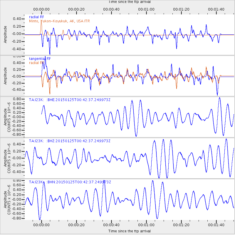
I23K Minto, Yukon-Koyukuk, AK, USA - Earthquake Result Viewer
*The percent match for this event was below the threshold and hence no stack was calculated.
| Earthquake location: |
Banda Sea |
| Earthquake latitude/longitude: |
-7.3/129.2 |
| Earthquake time(UTC): |
2015/01/25 (025) 00:30:12 GMT |
| Earthquake Depth: |
150 km |
| Earthquake Magnitude: |
4.8 mb, 4.7 mb |
| Earthquake Catalog/Contributor: |
ISC/ISC |
|
| Network: |
TA USArray Transportable Network (new EarthScope stations) |
| Station: |
I23K Minto, Yukon-Koyukuk, AK, USA |
| Lat/Lon: |
65.15 N/149.36 W |
| Elevation: |
149 m |
|
| Distance: |
93.0 deg |
| Az: |
24.739 deg |
| Baz: |
259.178 deg |
| Ray Param: |
$rayparam |
*The percent match for this event was below the threshold and hence was not used in the summary stack. |
|
| Radial Match: |
45.21311 % |
| Radial Bump: |
393 |
| Transverse Match: |
51.976627 % |
| Transverse Bump: |
289 |
| SOD ConfigId: |
3390531 |
| Insert Time: |
2019-04-16 03:53:14.529 +0000 |
| GWidth: |
2.5 |
| Max Bumps: |
400 |
| Tol: |
0.001 |
|
Signal To Noise
| Channel | StoN | STA | LTA |
| TA:I23K: :BHZ:20150125T00:42:37.249973Z | 0.9857325 | 1.642016E-7 | 1.6657826E-7 |
| TA:I23K: :BHN:20150125T00:42:37.249973Z | 1.8384187 | 4.8440654E-7 | 2.6349088E-7 |
| TA:I23K: :BHE:20150125T00:42:37.249973Z | 0.8661528 | 1.7709608E-7 | 2.0446286E-7 |
| Arrivals |
| Ps | |
| PpPs | |
| PsPs/PpSs | |


