You are here: Home > Network List > TA - USArray Transportable Network (new EarthScope stations) Stations List
> Station R49A Shelbyville, KY, USA > Earthquake Result Viewer
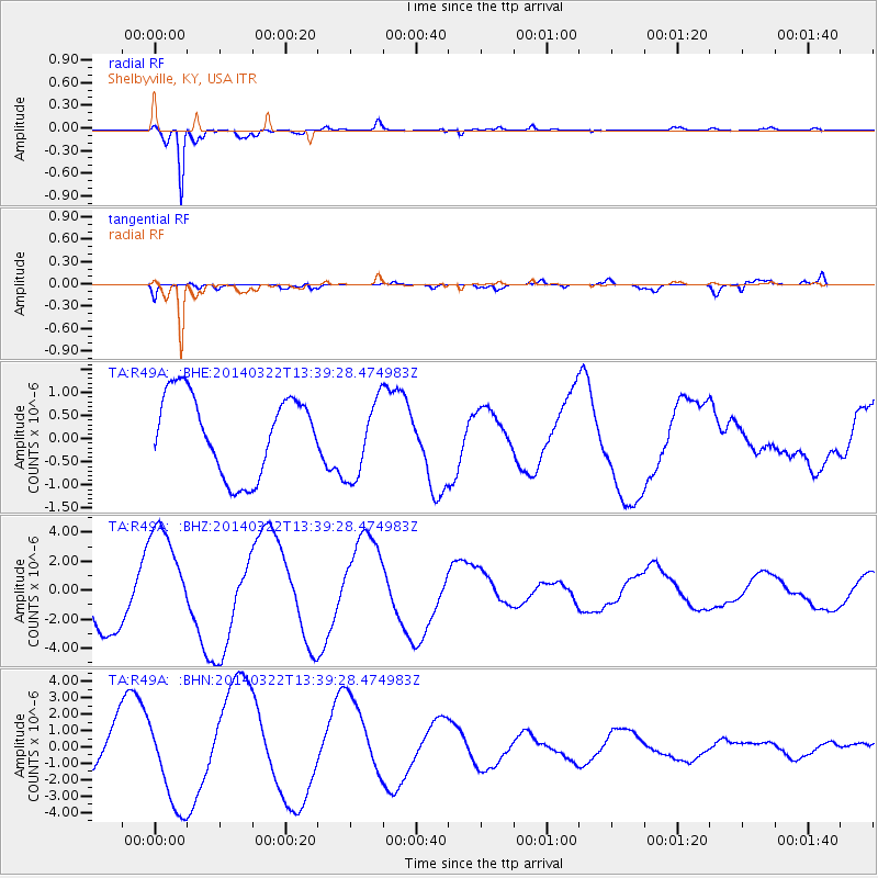
R49A Shelbyville, KY, USA - Earthquake Result Viewer
*The percent match for this event was below the threshold and hence no stack was calculated.
| Earthquake location: |
Near Coast Of Northern Chile |
| Earthquake latitude/longitude: |
-19.8/-71.0 |
| Earthquake time(UTC): |
2014/03/22 (081) 13:29:57 GMT |
| Earthquake Depth: |
10 km |
| Earthquake Magnitude: |
5.5 MB, 5.4 MWR, 5.6 MWW, 5.6 MWC |
| Earthquake Catalog/Contributor: |
NEIC PDE/NEIC COMCAT |
|
| Network: |
TA USArray Transportable Network (new EarthScope stations) |
| Station: |
R49A Shelbyville, KY, USA |
| Lat/Lon: |
38.29 N/85.17 W |
| Elevation: |
251 m |
|
| Distance: |
59.3 deg |
| Az: |
347.025 deg |
| Baz: |
164.411 deg |
| Ray Param: |
$rayparam |
*The percent match for this event was below the threshold and hence was not used in the summary stack. |
|
| Radial Match: |
94.87192 % |
| Radial Bump: |
306 |
| Transverse Match: |
32.523563 % |
| Transverse Bump: |
400 |
| SOD ConfigId: |
626651 |
| Insert Time: |
2014-04-21 11:07:42.737 +0000 |
| GWidth: |
2.5 |
| Max Bumps: |
400 |
| Tol: |
0.001 |
|
Signal To Noise
| Channel | StoN | STA | LTA |
| TA:R49A: :BHZ:20140322T13:39:28.474983Z | 2.0331073 | 3.769784E-6 | 1.8541981E-6 |
| TA:R49A: :BHN:20140322T13:39:28.474983Z | 1.9549202 | 2.7757426E-6 | 1.4198752E-6 |
| TA:R49A: :BHE:20140322T13:39:28.474983Z | 0.9914054 | 8.473869E-7 | 8.54733E-7 |
| Arrivals |
| Ps | |
| PpPs | |
| PsPs/PpSs | |


