You are here: Home > Network List > TA - USArray Transportable Network (new EarthScope stations) Stations List
> Station V57A Coltrane Farms, NC, USA > Earthquake Result Viewer
V57A Coltrane Farms, NC, USA - Earthquake Result Viewer

| Earthquake location: |
Near Coast Of Northern Chile |
| Earthquake latitude/longitude: |
-19.8/-71.0 |
| Earthquake time(UTC): |
2014/03/22 (081) 13:29:57 GMT |
| Earthquake Depth: |
10 km |
| Earthquake Magnitude: |
5.5 MB, 5.4 MWR, 5.6 MWW, 5.6 MWC |
| Earthquake Catalog/Contributor: |
NEIC PDE/NEIC COMCAT |
|
| Network: |
TA USArray Transportable Network (new EarthScope stations) |
| Station: |
V57A Coltrane Farms, NC, USA |
| Lat/Lon: |
35.89 N/79.78 W |
| Elevation: |
223 m |
|
| Distance: |
56.0 deg |
| Az: |
351.377 deg |
| Baz: |
169.986 deg |
| Ray Param: |
0.064441614 |
| Estimated Moho Depth: |
35.0 km |
| Estimated Crust Vp/Vs: |
1.61 |
| Assumed Crust Vp: |
6.565 km/s |
| Estimated Crust Vs: |
4.09 km/s |
| Estimated Crust Poisson's Ratio: |
0.18 |
|
| Radial Match: |
84.12672 % |
| Radial Bump: |
400 |
| Transverse Match: |
87.09738 % |
| Transverse Bump: |
376 |
| SOD ConfigId: |
626651 |
| Insert Time: |
2014-04-21 11:08:47.030 +0000 |
| GWidth: |
2.5 |
| Max Bumps: |
400 |
| Tol: |
0.001 |
|
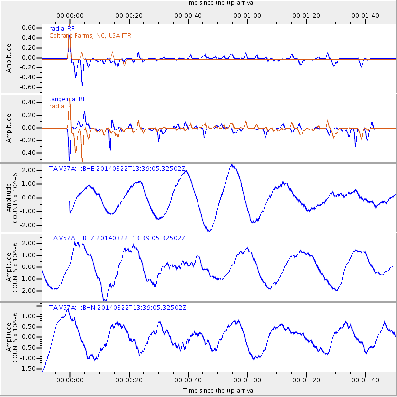
Signal To Noise
| Channel | StoN | STA | LTA |
| TA:V57A: :BHZ:20140322T13:39:05.32502Z | 1.4112971 | 1.6411204E-6 | 1.1628454E-6 |
| TA:V57A: :BHN:20140322T13:39:05.32502Z | 0.8825685 | 9.824041E-7 | 1.1131194E-6 |
| TA:V57A: :BHE:20140322T13:39:05.32502Z | 1.6692499 | 1.2552788E-6 | 7.5200177E-7 |
| Arrivals |
| Ps | 3.4 SECOND |
| PpPs | 13 SECOND |
| PsPs/PpSs | 17 SECOND |


