You are here: Home > Network List > IU - Global Seismograph Network (GSN - IRIS/USGS) Stations List
> Station RSSD Black Hills, South Dakota, USA > Earthquake Result Viewer
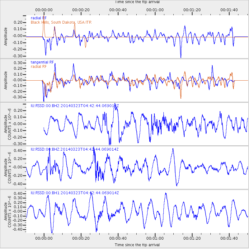
RSSD Black Hills, South Dakota, USA - Earthquake Result Viewer
*The percent match for this event was below the threshold and hence no stack was calculated.
| Earthquake location: |
Fiji Islands Region |
| Earthquake latitude/longitude: |
-20.7/-178.8 |
| Earthquake time(UTC): |
2014/03/23 (082) 04:31:02 GMT |
| Earthquake Depth: |
607 km |
| Earthquake Magnitude: |
5.7 MWP, 5.9 MWC, 5.9 MWB |
| Earthquake Catalog/Contributor: |
NEIC PDE/NEIC COMCAT |
|
| Network: |
IU Global Seismograph Network (GSN - IRIS/USGS) |
| Station: |
RSSD Black Hills, South Dakota, USA |
| Lat/Lon: |
44.12 N/104.04 W |
| Elevation: |
2090 m |
|
| Distance: |
93.8 deg |
| Az: |
44.148 deg |
| Baz: |
244.916 deg |
| Ray Param: |
$rayparam |
*The percent match for this event was below the threshold and hence was not used in the summary stack. |
|
| Radial Match: |
44.634792 % |
| Radial Bump: |
400 |
| Transverse Match: |
46.179295 % |
| Transverse Bump: |
370 |
| SOD ConfigId: |
626651 |
| Insert Time: |
2014-04-21 11:24:49.820 +0000 |
| GWidth: |
2.5 |
| Max Bumps: |
400 |
| Tol: |
0.001 |
|
Signal To Noise
| Channel | StoN | STA | LTA |
| IU:RSSD:00:BHZ:20140323T04:42:44.069014Z | 1.2595223 | 1.5916605E-7 | 1.2637018E-7 |
| IU:RSSD:00:BH1:20140323T04:42:44.069014Z | 1.8371384 | 2.639493E-7 | 1.4367414E-7 |
| IU:RSSD:00:BH2:20140323T04:42:44.069014Z | 1.0543114 | 9.9336056E-8 | 9.42189E-8 |
| Arrivals |
| Ps | |
| PpPs | |
| PsPs/PpSs | |


