You are here: Home > Network List > TA - USArray Transportable Network (new EarthScope stations) Stations List
> Station N23A Red Feather Lakes, CO, USA > Earthquake Result Viewer
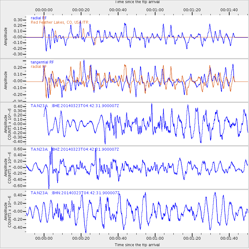
N23A Red Feather Lakes, CO, USA - Earthquake Result Viewer
*The percent match for this event was below the threshold and hence no stack was calculated.
| Earthquake location: |
Fiji Islands Region |
| Earthquake latitude/longitude: |
-20.7/-178.8 |
| Earthquake time(UTC): |
2014/03/23 (082) 04:31:02 GMT |
| Earthquake Depth: |
607 km |
| Earthquake Magnitude: |
5.7 MWP, 5.9 MWC, 5.9 MWB |
| Earthquake Catalog/Contributor: |
NEIC PDE/NEIC COMCAT |
|
| Network: |
TA USArray Transportable Network (new EarthScope stations) |
| Station: |
N23A Red Feather Lakes, CO, USA |
| Lat/Lon: |
40.89 N/105.94 W |
| Elevation: |
2458 m |
|
| Distance: |
91.1 deg |
| Az: |
46.439 deg |
| Baz: |
243.532 deg |
| Ray Param: |
$rayparam |
*The percent match for this event was below the threshold and hence was not used in the summary stack. |
|
| Radial Match: |
59.678482 % |
| Radial Bump: |
400 |
| Transverse Match: |
34.38423 % |
| Transverse Bump: |
365 |
| SOD ConfigId: |
626651 |
| Insert Time: |
2014-04-21 11:31:10.083 +0000 |
| GWidth: |
2.5 |
| Max Bumps: |
400 |
| Tol: |
0.001 |
|
Signal To Noise
| Channel | StoN | STA | LTA |
| TA:N23A: :BHZ:20140323T04:42:31.900007Z | 3.0751278 | 2.8999418E-7 | 9.4303125E-8 |
| TA:N23A: :BHN:20140323T04:42:31.900007Z | 1.3307389 | 1.8441874E-7 | 1.3858372E-7 |
| TA:N23A: :BHE:20140323T04:42:31.900007Z | 1.1290556 | 1.5931629E-7 | 1.4110579E-7 |
| Arrivals |
| Ps | |
| PpPs | |
| PsPs/PpSs | |


