You are here: Home > Network List > US - United States National Seismic Network Stations List
> Station HAWA Hanford, Washington, USA > Earthquake Result Viewer
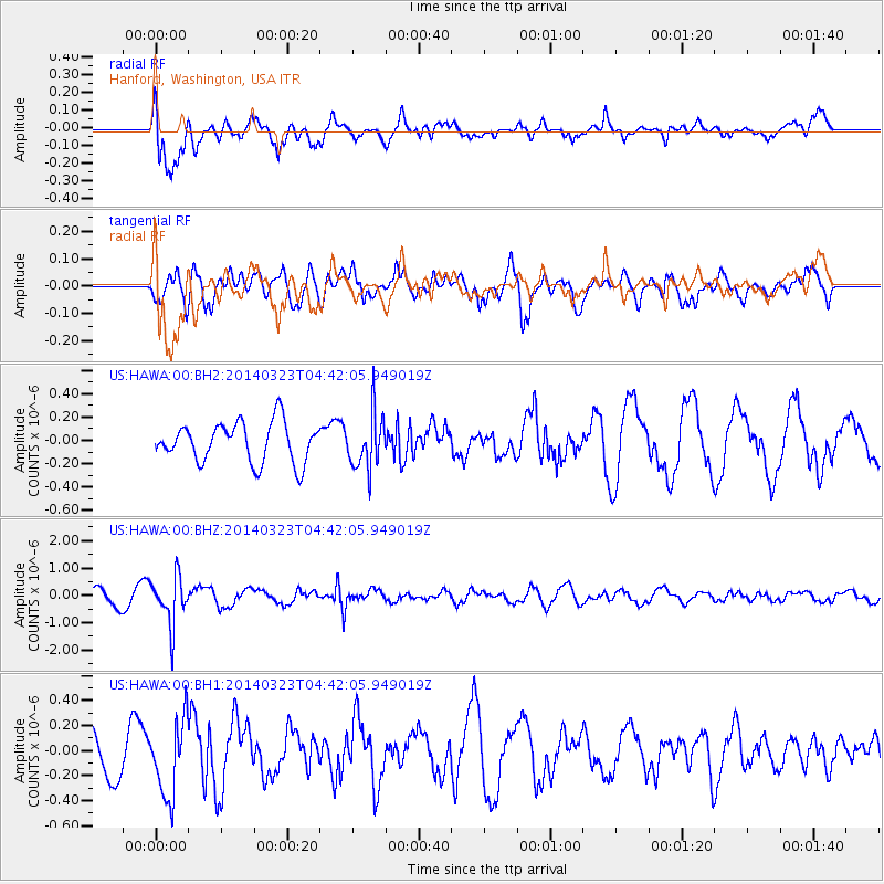
HAWA Hanford, Washington, USA - Earthquake Result Viewer
*The percent match for this event was below the threshold and hence no stack was calculated.
| Earthquake location: |
Fiji Islands Region |
| Earthquake latitude/longitude: |
-20.7/-178.8 |
| Earthquake time(UTC): |
2014/03/23 (082) 04:31:02 GMT |
| Earthquake Depth: |
607 km |
| Earthquake Magnitude: |
5.7 MWP, 5.9 MWC, 5.9 MWB |
| Earthquake Catalog/Contributor: |
NEIC PDE/NEIC COMCAT |
|
| Network: |
US United States National Seismic Network |
| Station: |
HAWA Hanford, Washington, USA |
| Lat/Lon: |
46.39 N/119.53 W |
| Elevation: |
364 m |
|
| Distance: |
85.5 deg |
| Az: |
36.649 deg |
| Baz: |
233.867 deg |
| Ray Param: |
$rayparam |
*The percent match for this event was below the threshold and hence was not used in the summary stack. |
|
| Radial Match: |
69.54602 % |
| Radial Bump: |
400 |
| Transverse Match: |
75.14646 % |
| Transverse Bump: |
400 |
| SOD ConfigId: |
626651 |
| Insert Time: |
2014-04-21 11:32:14.388 +0000 |
| GWidth: |
2.5 |
| Max Bumps: |
400 |
| Tol: |
0.001 |
|
Signal To Noise
| Channel | StoN | STA | LTA |
| US:HAWA:00:BHZ:20140323T04:42:05.949019Z | 3.3179817 | 8.7863646E-7 | 2.6481052E-7 |
| US:HAWA:00:BH1:20140323T04:42:05.949019Z | 1.6027458 | 3.0444255E-7 | 1.8995063E-7 |
| US:HAWA:00:BH2:20140323T04:42:05.949019Z | 1.378811 | 2.3310973E-7 | 1.6906576E-7 |
| Arrivals |
| Ps | |
| PpPs | |
| PsPs/PpSs | |


