You are here: Home > Network List > UW - Pacific Northwest Regional Seismic Network Stations List
> Station UMAT Pilot Rock, OR, USA > Earthquake Result Viewer
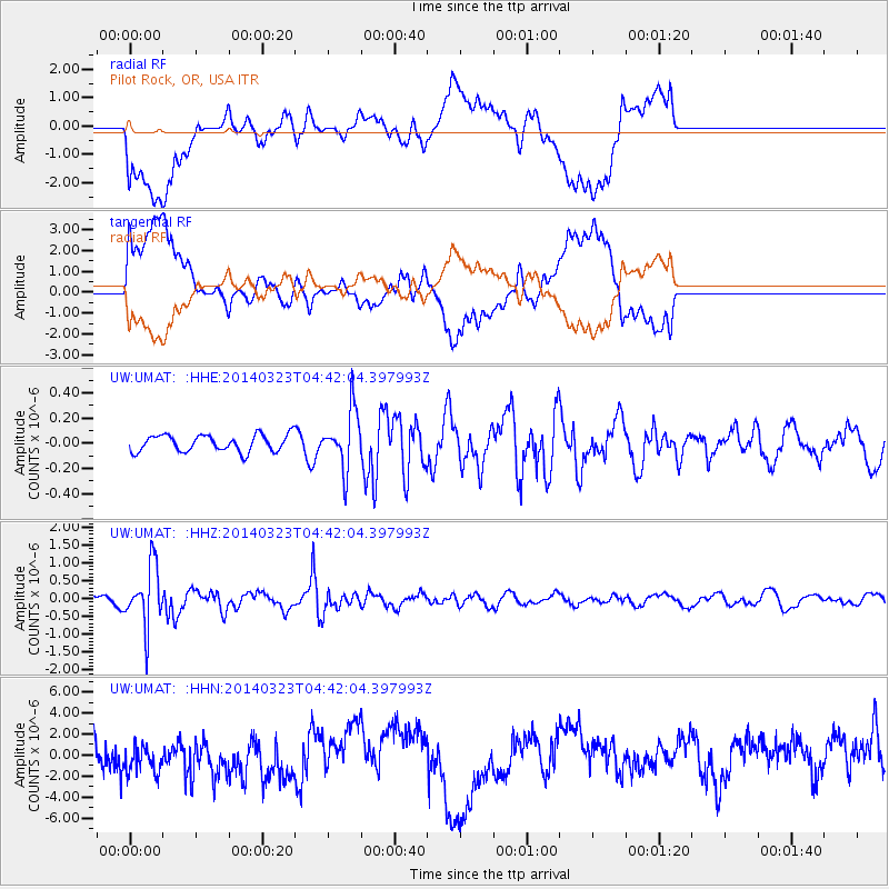
UMAT Pilot Rock, OR, USA - Earthquake Result Viewer
*The percent match for this event was below the threshold and hence no stack was calculated.
| Earthquake location: |
Fiji Islands Region |
| Earthquake latitude/longitude: |
-20.7/-178.8 |
| Earthquake time(UTC): |
2014/03/23 (082) 04:31:02 GMT |
| Earthquake Depth: |
607 km |
| Earthquake Magnitude: |
5.7 MWP, 5.9 MWC, 5.9 MWB |
| Earthquake Catalog/Contributor: |
NEIC PDE/NEIC COMCAT |
|
| Network: |
UW Pacific Northwest Regional Seismic Network |
| Station: |
UMAT Pilot Rock, OR, USA |
| Lat/Lon: |
45.29 N/118.96 W |
| Elevation: |
1318 m |
|
| Distance: |
85.2 deg |
| Az: |
37.781 deg |
| Baz: |
234.368 deg |
| Ray Param: |
$rayparam |
*The percent match for this event was below the threshold and hence was not used in the summary stack. |
|
| Radial Match: |
48.116913 % |
| Radial Bump: |
400 |
| Transverse Match: |
48.080467 % |
| Transverse Bump: |
400 |
| SOD ConfigId: |
626651 |
| Insert Time: |
2014-04-21 11:34:54.832 +0000 |
| GWidth: |
2.5 |
| Max Bumps: |
400 |
| Tol: |
0.001 |
|
Signal To Noise
| Channel | StoN | STA | LTA |
| UW:UMAT: :HHZ:20140323T04:42:04.397993Z | 5.6144347 | 8.322283E-7 | 1.4823011E-7 |
| UW:UMAT: :HHN:20140323T04:42:04.397993Z | 1.0204095 | 2.3634102E-6 | 2.316139E-6 |
| UW:UMAT: :HHE:20140323T04:42:04.397993Z | 3.4506607 | 2.2685289E-7 | 6.574187E-8 |
| Arrivals |
| Ps | |
| PpPs | |
| PsPs/PpSs | |


