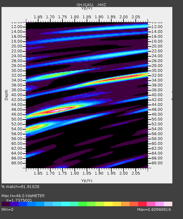
KUKU Kukurantumi, Ghana - Earthquake Result Viewer

Earthquake location: Near Coast Of Northern Chile
Earthquake latitude/longitude: -19.7/-70.8
Earthquake time(UTC): 2014/03/23 (082) 18:20:03 GMT
Earthquake Depth: 35 km
Earthquake Magnitude: 6.0 MB, 6.2 MWB, 6.2 MWW, 6.3 MWC
Earthquake Catalog/Contributor: NEIC PDE/NEIC COMCAT
Network: GH Ghana Digital Seismic Network
Station: KUKU Kukurantumi, Ghana
Lat/Lon: 6.19 N/0.37 W
Elevation: 240 m
Distance: 73.9 deg
Az: 77.209 deg
Baz: 247.499 deg
Ray Param: 0.05265161
Estimated Moho Depth: 46.0 km
Estimated Crust Vp/Vs: 1.74
Assumed Crust Vp: 6.419 km/s
Estimated Crust Vs: 3.695 km/s
Estimated Crust Poisson's Ratio: 0.25
Radial Match: 91.91828 %
Radial Bump: 400
Transverse Match: 70.05909 %
Transverse Bump: 400
SOD ConfigId: 626651
Insert Time: 2014-04-21 11:44:13.563 +0000
GWidth: 2.5
Max Bumps: 400
Tol: 0.001

Signal To Noise

ChannelStoNSTALTA
GH:KUKU: :HHZ:20140323T18:31:04.020002Z9.1527311.1570479E-61.2641559E-7
GH:KUKU: :HHN:20140323T18:31:04.020002Z3.41286542.1652076E-76.344251E-8
GH:KUKU: :HHE:20140323T18:31:04.020002Z6.65398654.5972473E-76.909012E-8
Arrivals
Ps5.5 SECOND
PpPs19 SECOND
PsPs/PpSs24 SECOND