You are here: Home > Network List > N4 - Central and EAstern US Network Stations List
> Station S44A Carbondale, IL, USA > Earthquake Result Viewer
S44A Carbondale, IL, USA - Earthquake Result Viewer
| Earthquake location: |
Near Coast Of Northern Chile |
| Earthquake latitude/longitude: |
-19.7/-70.8 |
| Earthquake time(UTC): |
2014/03/23 (082) 18:20:03 GMT |
| Earthquake Depth: |
35 km |
| Earthquake Magnitude: |
6.0 MB, 6.2 MWB, 6.2 MWW, 6.3 MWC |
| Earthquake Catalog/Contributor: |
NEIC PDE/NEIC COMCAT |
|
| Network: |
N4 Central and EAstern US Network |
| Station: |
S44A Carbondale, IL, USA |
| Lat/Lon: |
37.69 N/89.26 W |
| Elevation: |
155 m |
|
| Distance: |
59.7 deg |
| Az: |
343.103 deg |
| Baz: |
159.811 deg |
| Ray Param: |
0.06194795 |
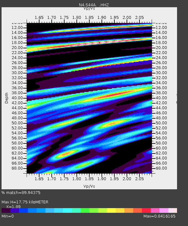
| Estimated Moho Depth: |
17.75 km |
| Estimated Crust Vp/Vs: |
1.89 |
| Assumed Crust Vp: |
6.444 km/s |
| Estimated Crust Vs: |
3.409 km/s |
| Estimated Crust Poisson's Ratio: |
0.31 |
|
| Radial Match: |
89.94375 % |
| Radial Bump: |
400 |
| Transverse Match: |
72.21614 % |
| Transverse Bump: |
400 |
| SOD ConfigId: |
626651 |
| Insert Time: |
2014-04-21 11:50:37.133 +0000 |
| GWidth: |
2.5 |
| Max Bumps: |
400 |
| Tol: |
0.001 |
|

Signal To Noise
| Channel | StoN | STA | LTA |
| N4:S44A: :HHZ:20140323T18:29:33.989973Z | 12.9199705 | 1.220955E-6 | 9.4501374E-8 |
| N4:S44A: :HHN:20140323T18:29:33.989973Z | 3.6151016 | 6.8923754E-7 | 1.906551E-7 |
| N4:S44A: :HHE:20140323T18:29:33.989973Z | 2.396995 | 2.7827065E-7 | 1.1609145E-7 |
| Arrivals |
| Ps | 2.6 SECOND |
| PpPs | 7.6 SECOND |
| PsPs/PpSs | 10 SECOND |


