You are here: Home > Network List > TA - USArray Transportable Network (new EarthScope stations) Stations List
> Station I47A Gladwin, MI, USA > Earthquake Result Viewer
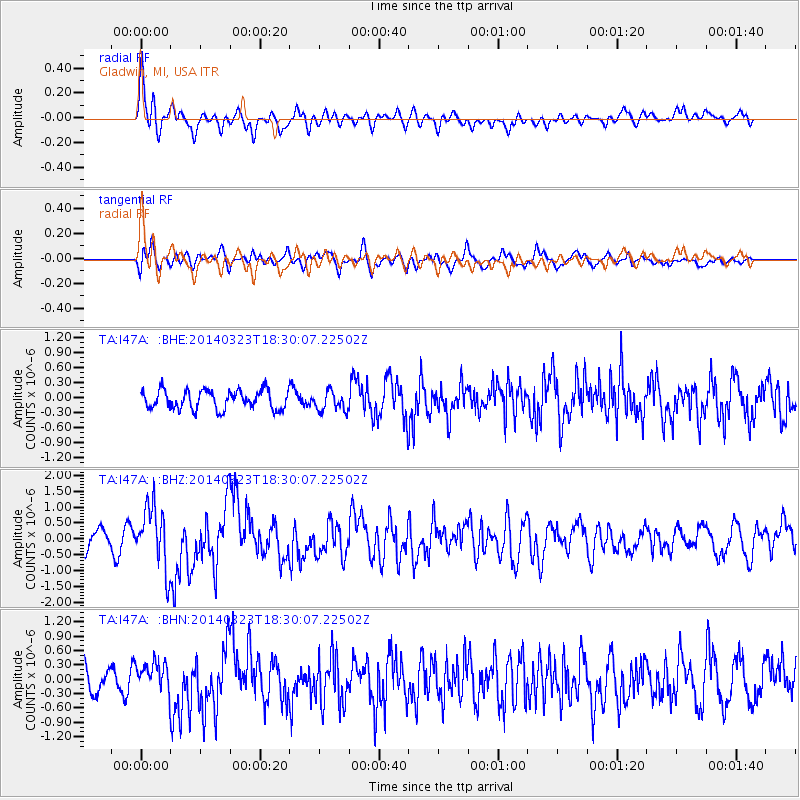
I47A Gladwin, MI, USA - Earthquake Result Viewer
*The percent match for this event was below the threshold and hence no stack was calculated.
| Earthquake location: |
Near Coast Of Northern Chile |
| Earthquake latitude/longitude: |
-19.7/-70.8 |
| Earthquake time(UTC): |
2014/03/23 (082) 18:20:03 GMT |
| Earthquake Depth: |
35 km |
| Earthquake Magnitude: |
6.0 MB, 6.2 MWB, 6.2 MWW, 6.3 MWC |
| Earthquake Catalog/Contributor: |
NEIC PDE/NEIC COMCAT |
|
| Network: |
TA USArray Transportable Network (new EarthScope stations) |
| Station: |
I47A Gladwin, MI, USA |
| Lat/Lon: |
44.02 N/84.51 W |
| Elevation: |
269 m |
|
| Distance: |
64.7 deg |
| Az: |
349.105 deg |
| Baz: |
165.713 deg |
| Ray Param: |
$rayparam |
*The percent match for this event was below the threshold and hence was not used in the summary stack. |
|
| Radial Match: |
68.20241 % |
| Radial Bump: |
400 |
| Transverse Match: |
54.337067 % |
| Transverse Bump: |
400 |
| SOD ConfigId: |
626651 |
| Insert Time: |
2014-04-21 12:00:01.639 +0000 |
| GWidth: |
2.5 |
| Max Bumps: |
400 |
| Tol: |
0.001 |
|
Signal To Noise
| Channel | StoN | STA | LTA |
| TA:I47A: :BHZ:20140323T18:30:07.22502Z | 4.0430155 | 9.732344E-7 | 2.407199E-7 |
| TA:I47A: :BHN:20140323T18:30:07.22502Z | 1.4551525 | 3.1685283E-7 | 2.1774545E-7 |
| TA:I47A: :BHE:20140323T18:30:07.22502Z | 1.0409558 | 1.9562296E-7 | 1.879263E-7 |
| Arrivals |
| Ps | |
| PpPs | |
| PsPs/PpSs | |


