You are here: Home > Network List > TA - USArray Transportable Network (new EarthScope stations) Stations List
> Station I52A Shelburne, ON, CAN > Earthquake Result Viewer
I52A Shelburne, ON, CAN - Earthquake Result Viewer
| Earthquake location: |
Near Coast Of Northern Chile |
| Earthquake latitude/longitude: |
-19.7/-70.8 |
| Earthquake time(UTC): |
2014/03/23 (082) 18:20:03 GMT |
| Earthquake Depth: |
35 km |
| Earthquake Magnitude: |
6.0 MB, 6.2 MWB, 6.2 MWW, 6.3 MWC |
| Earthquake Catalog/Contributor: |
NEIC PDE/NEIC COMCAT |
|
| Network: |
TA USArray Transportable Network (new EarthScope stations) |
| Station: |
I52A Shelburne, ON, CAN |
| Lat/Lon: |
44.07 N/80.18 W |
| Elevation: |
505 m |
|
| Distance: |
64.1 deg |
| Az: |
352.505 deg |
| Baz: |
170.186 deg |
| Ray Param: |
0.059099723 |
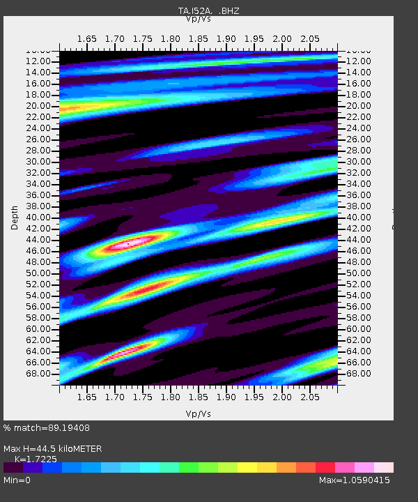
| Estimated Moho Depth: |
44.5 km |
| Estimated Crust Vp/Vs: |
1.72 |
| Assumed Crust Vp: |
6.53 km/s |
| Estimated Crust Vs: |
3.791 km/s |
| Estimated Crust Poisson's Ratio: |
0.25 |
|
| Radial Match: |
89.19408 % |
| Radial Bump: |
400 |
| Transverse Match: |
61.596157 % |
| Transverse Bump: |
400 |
| SOD ConfigId: |
626651 |
| Insert Time: |
2014-04-21 12:00:13.212 +0000 |
| GWidth: |
2.5 |
| Max Bumps: |
400 |
| Tol: |
0.001 |
|

Signal To Noise
| Channel | StoN | STA | LTA |
| TA:I52A: :BHZ:20140323T18:30:03.27397Z | 10.018706 | 1.2391263E-6 | 1.2368127E-7 |
| TA:I52A: :BHN:20140323T18:30:03.27397Z | 6.0521255 | 8.8363703E-7 | 1.4600441E-7 |
| TA:I52A: :BHE:20140323T18:30:03.27397Z | 1.2078892 | 1.826437E-7 | 1.5120898E-7 |
| Arrivals |
| Ps | 5.2 SECOND |
| PpPs | 18 SECOND |
| PsPs/PpSs | 23 SECOND |


