You are here: Home > Network List > TA - USArray Transportable Network (new EarthScope stations) Stations List
> Station J46A Howard City, MI, USA > Earthquake Result Viewer
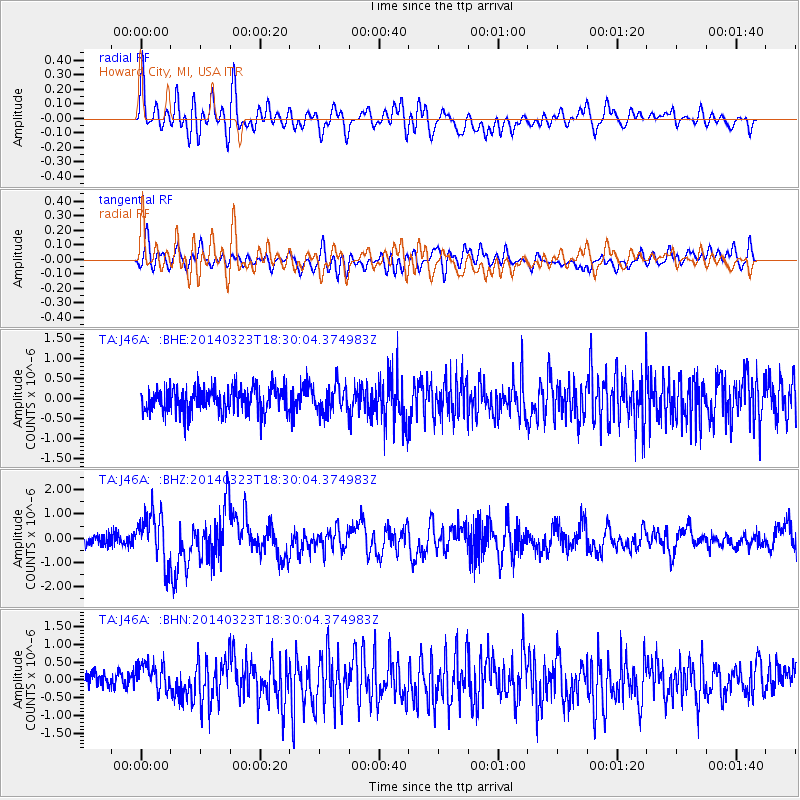
J46A Howard City, MI, USA - Earthquake Result Viewer
*The percent match for this event was below the threshold and hence no stack was calculated.
| Earthquake location: |
Near Coast Of Northern Chile |
| Earthquake latitude/longitude: |
-19.7/-70.8 |
| Earthquake time(UTC): |
2014/03/23 (082) 18:20:03 GMT |
| Earthquake Depth: |
35 km |
| Earthquake Magnitude: |
6.0 MB, 6.2 MWB, 6.2 MWW, 6.3 MWC |
| Earthquake Catalog/Contributor: |
NEIC PDE/NEIC COMCAT |
|
| Network: |
TA USArray Transportable Network (new EarthScope stations) |
| Station: |
J46A Howard City, MI, USA |
| Lat/Lon: |
43.35 N/85.65 W |
| Elevation: |
275 m |
|
| Distance: |
64.2 deg |
| Az: |
348.03 deg |
| Baz: |
164.467 deg |
| Ray Param: |
$rayparam |
*The percent match for this event was below the threshold and hence was not used in the summary stack. |
|
| Radial Match: |
71.57813 % |
| Radial Bump: |
400 |
| Transverse Match: |
57.127308 % |
| Transverse Bump: |
400 |
| SOD ConfigId: |
626651 |
| Insert Time: |
2014-04-21 12:00:40.213 +0000 |
| GWidth: |
2.5 |
| Max Bumps: |
400 |
| Tol: |
0.001 |
|
Signal To Noise
| Channel | StoN | STA | LTA |
| TA:J46A: :BHZ:20140323T18:30:04.374983Z | 3.8561692 | 1.0363801E-6 | 2.6875898E-7 |
| TA:J46A: :BHN:20140323T18:30:04.374983Z | 1.8259596 | 4.69591E-7 | 2.5717492E-7 |
| TA:J46A: :BHE:20140323T18:30:04.374983Z | 1.0581735 | 3.2950484E-7 | 3.1139018E-7 |
| Arrivals |
| Ps | |
| PpPs | |
| PsPs/PpSs | |


