You are here: Home > Network List > TA - USArray Transportable Network (new EarthScope stations) Stations List
> Station J54A Appleton, NY, USA > Earthquake Result Viewer
J54A Appleton, NY, USA - Earthquake Result Viewer
| Earthquake location: |
Near Coast Of Northern Chile |
| Earthquake latitude/longitude: |
-19.7/-70.8 |
| Earthquake time(UTC): |
2014/03/23 (082) 18:20:03 GMT |
| Earthquake Depth: |
35 km |
| Earthquake Magnitude: |
6.0 MB, 6.2 MWB, 6.2 MWW, 6.3 MWC |
| Earthquake Catalog/Contributor: |
NEIC PDE/NEIC COMCAT |
|
| Network: |
TA USArray Transportable Network (new EarthScope stations) |
| Station: |
J54A Appleton, NY, USA |
| Lat/Lon: |
43.27 N/78.64 W |
| Elevation: |
112 m |
|
| Distance: |
63.1 deg |
| Az: |
353.596 deg |
| Baz: |
171.73 deg |
| Ray Param: |
0.05972828 |
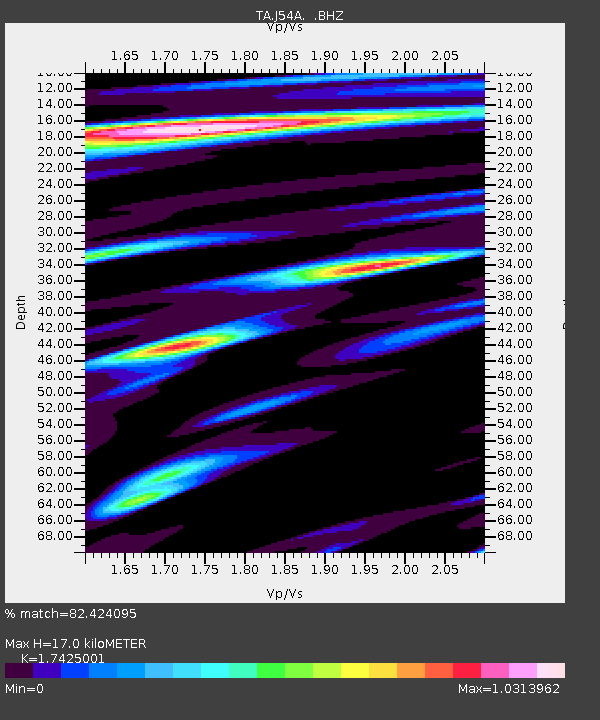
| Estimated Moho Depth: |
17.0 km |
| Estimated Crust Vp/Vs: |
1.74 |
| Assumed Crust Vp: |
6.419 km/s |
| Estimated Crust Vs: |
3.684 km/s |
| Estimated Crust Poisson's Ratio: |
0.25 |
|
| Radial Match: |
82.424095 % |
| Radial Bump: |
400 |
| Transverse Match: |
55.966812 % |
| Transverse Bump: |
400 |
| SOD ConfigId: |
626651 |
| Insert Time: |
2014-04-21 12:00:53.306 +0000 |
| GWidth: |
2.5 |
| Max Bumps: |
400 |
| Tol: |
0.001 |
|
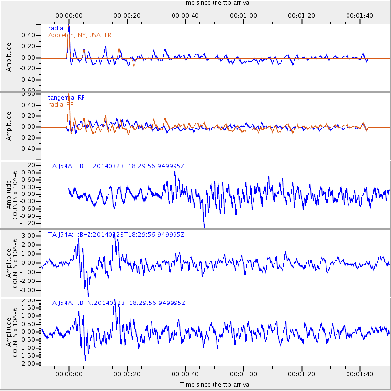
Signal To Noise
| Channel | StoN | STA | LTA |
| TA:J54A: :BHZ:20140323T18:29:56.949995Z | 5.2668667 | 1.1086603E-6 | 2.1049713E-7 |
| TA:J54A: :BHN:20140323T18:29:56.949995Z | 3.873143 | 5.8901793E-7 | 1.520775E-7 |
| TA:J54A: :BHE:20140323T18:29:56.949995Z | 1.1127888 | 2.3732508E-7 | 2.1327055E-7 |
| Arrivals |
| Ps | 2.1 SECOND |
| PpPs | 6.9 SECOND |
| PsPs/PpSs | 9.0 SECOND |


