You are here: Home > Network List > GS - US Geological Survey Networks Stations List
> Station KAN13 Rinehart Farm > Earthquake Result Viewer
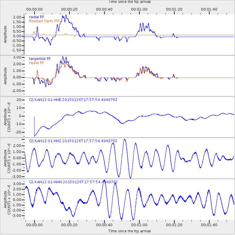
KAN13 Rinehart Farm - Earthquake Result Viewer
*The percent match for this event was below the threshold and hence no stack was calculated.
| Earthquake location: |
Pacific-Antarctic Ridge |
| Earthquake latitude/longitude: |
-54.7/-136.9 |
| Earthquake time(UTC): |
2015/01/26 (026) 17:44:52 GMT |
| Earthquake Depth: |
10 km |
| Earthquake Magnitude: |
5.6 MW, 4.4 mb, 5.0 MS |
| Earthquake Catalog/Contributor: |
ISC/ISC |
|
| Network: |
GS US Geological Survey Networks |
| Station: |
KAN13 Rinehart Farm |
| Lat/Lon: |
37.01 N/97.48 W |
| Elevation: |
340 m |
|
| Distance: |
97.4 deg |
| Az: |
30.798 deg |
| Baz: |
201.811 deg |
| Ray Param: |
$rayparam |
*The percent match for this event was below the threshold and hence was not used in the summary stack. |
|
| Radial Match: |
42.972004 % |
| Radial Bump: |
400 |
| Transverse Match: |
30.97588 % |
| Transverse Bump: |
400 |
| SOD ConfigId: |
3390531 |
| Insert Time: |
2019-04-16 04:14:52.774 +0000 |
| GWidth: |
2.5 |
| Max Bumps: |
400 |
| Tol: |
0.001 |
|
Signal To Noise
| Channel | StoN | STA | LTA |
| GS:KAN13:01:HHZ:20150126T17:57:54.494976Z | 0.68541074 | 1.0481368E-6 | 1.5292097E-6 |
| GS:KAN13:01:HHN:20150126T17:57:54.494976Z | 1.3334886 | 2.8080594E-6 | 2.1057995E-6 |
| GS:KAN13:01:HHE:20150126T17:57:54.494976Z | 1.6956183 | 1.3944487E-5 | 8.223837E-6 |
| Arrivals |
| Ps | |
| PpPs | |
| PsPs/PpSs | |


