You are here: Home > Network List > TA - USArray Transportable Network (new EarthScope stations) Stations List
> Station M59A Waymart, PA, USA > Earthquake Result Viewer
M59A Waymart, PA, USA - Earthquake Result Viewer
| Earthquake location: |
Near Coast Of Northern Chile |
| Earthquake latitude/longitude: |
-19.7/-70.8 |
| Earthquake time(UTC): |
2014/03/23 (082) 18:20:03 GMT |
| Earthquake Depth: |
35 km |
| Earthquake Magnitude: |
6.0 MB, 6.2 MWB, 6.2 MWW, 6.3 MWC |
| Earthquake Catalog/Contributor: |
NEIC PDE/NEIC COMCAT |
|
| Network: |
TA USArray Transportable Network (new EarthScope stations) |
| Station: |
M59A Waymart, PA, USA |
| Lat/Lon: |
41.54 N/75.43 W |
| Elevation: |
471 m |
|
| Distance: |
61.1 deg |
| Az: |
356.039 deg |
| Baz: |
175.028 deg |
| Ray Param: |
0.061019275 |
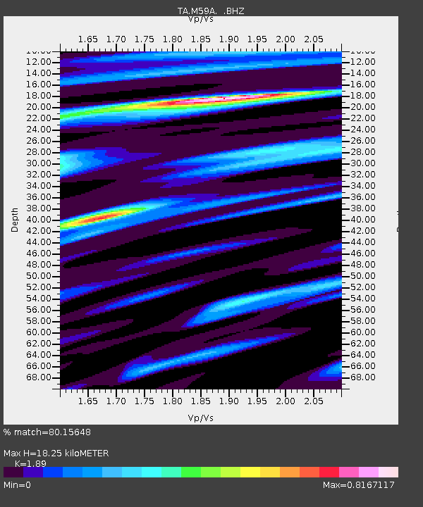
| Estimated Moho Depth: |
18.25 km |
| Estimated Crust Vp/Vs: |
1.89 |
| Assumed Crust Vp: |
6.283 km/s |
| Estimated Crust Vs: |
3.325 km/s |
| Estimated Crust Poisson's Ratio: |
0.31 |
|
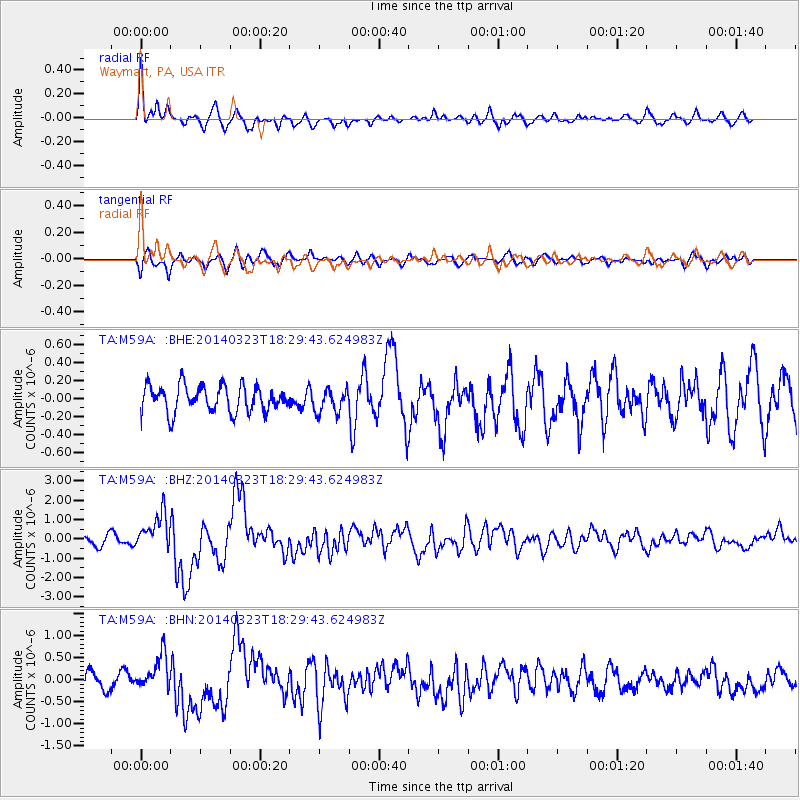
| Radial Match: |
80.15648 % |
| Radial Bump: |
400 |
| Transverse Match: |
67.17792 % |
| Transverse Bump: |
400 |
| SOD ConfigId: |
626651 |
| Insert Time: |
2014-04-21 12:03:51.159 +0000 |
| GWidth: |
2.5 |
| Max Bumps: |
400 |
| Tol: |
0.001 |
|
Signal To Noise
| Channel | StoN | STA | LTA |
| TA:M59A: :BHZ:20140323T18:29:43.624983Z | 3.9827485 | 9.320733E-7 | 2.3402765E-7 |
| TA:M59A: :BHN:20140323T18:29:43.624983Z | 1.822276 | 3.7141228E-7 | 2.0381779E-7 |
| TA:M59A: :BHE:20140323T18:29:43.624983Z | 0.89436823 | 1.3113208E-7 | 1.4661978E-7 |
| Arrivals |
| Ps | 2.7 SECOND |
| PpPs | 8.1 SECOND |
| PsPs/PpSs | 11 SECOND |


