You are here: Home > Network List > TA - USArray Transportable Network (new EarthScope stations) Stations List
> Station P50A Jamestown, OH, USA > Earthquake Result Viewer
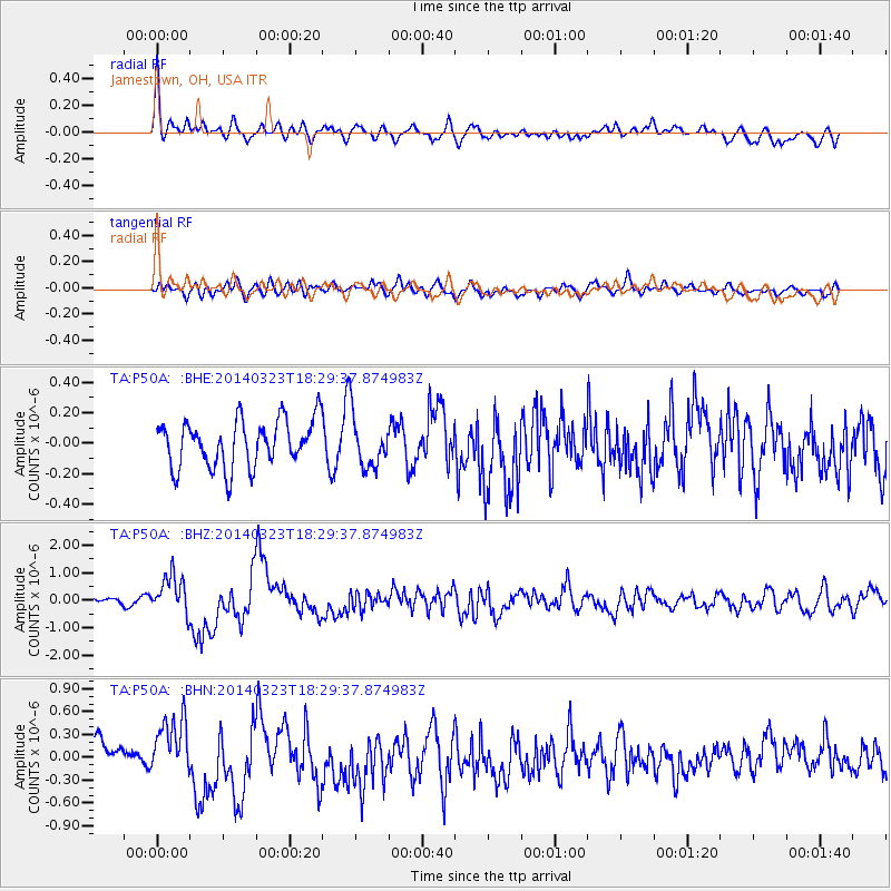
P50A Jamestown, OH, USA - Earthquake Result Viewer
*The percent match for this event was below the threshold and hence no stack was calculated.
| Earthquake location: |
Near Coast Of Northern Chile |
| Earthquake latitude/longitude: |
-19.7/-70.8 |
| Earthquake time(UTC): |
2014/03/23 (082) 18:20:03 GMT |
| Earthquake Depth: |
35 km |
| Earthquake Magnitude: |
6.0 MB, 6.2 MWB, 6.2 MWW, 6.3 MWC |
| Earthquake Catalog/Contributor: |
NEIC PDE/NEIC COMCAT |
|
| Network: |
TA USArray Transportable Network (new EarthScope stations) |
| Station: |
P50A Jamestown, OH, USA |
| Lat/Lon: |
39.61 N/83.80 W |
| Elevation: |
318 m |
|
| Distance: |
60.3 deg |
| Az: |
348.467 deg |
| Baz: |
165.891 deg |
| Ray Param: |
$rayparam |
*The percent match for this event was below the threshold and hence was not used in the summary stack. |
|
| Radial Match: |
75.975525 % |
| Radial Bump: |
400 |
| Transverse Match: |
55.266434 % |
| Transverse Bump: |
400 |
| SOD ConfigId: |
626651 |
| Insert Time: |
2014-04-21 12:05:50.008 +0000 |
| GWidth: |
2.5 |
| Max Bumps: |
400 |
| Tol: |
0.001 |
|
Signal To Noise
| Channel | StoN | STA | LTA |
| TA:P50A: :BHZ:20140323T18:29:37.874983Z | 5.2489767 | 7.122796E-7 | 1.3569874E-7 |
| TA:P50A: :BHN:20140323T18:29:37.874983Z | 1.9701898 | 3.7103058E-7 | 1.8832226E-7 |
| TA:P50A: :BHE:20140323T18:29:37.874983Z | 1.1445963 | 1.7463519E-7 | 1.525736E-7 |
| Arrivals |
| Ps | |
| PpPs | |
| PsPs/PpSs | |


