You are here: Home > Network List > TA - USArray Transportable Network (new EarthScope stations) Stations List
> Station R11A Troy Canyon, Currant, NV, USA > Earthquake Result Viewer
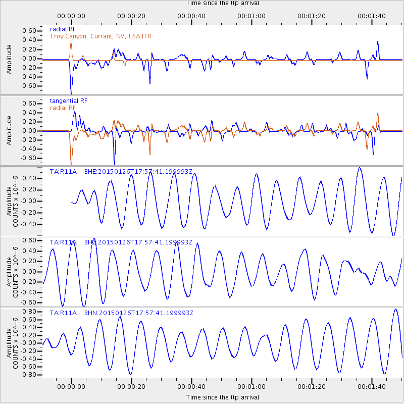
R11A Troy Canyon, Currant, NV, USA - Earthquake Result Viewer
*The percent match for this event was below the threshold and hence no stack was calculated.
| Earthquake location: |
Pacific-Antarctic Ridge |
| Earthquake latitude/longitude: |
-54.7/-136.9 |
| Earthquake time(UTC): |
2015/01/26 (026) 17:44:52 GMT |
| Earthquake Depth: |
10 km |
| Earthquake Magnitude: |
5.6 MW, 4.4 mb, 5.0 MS |
| Earthquake Catalog/Contributor: |
ISC/ISC |
|
| Network: |
TA USArray Transportable Network (new EarthScope stations) |
| Station: |
R11A Troy Canyon, Currant, NV, USA |
| Lat/Lon: |
38.35 N/115.59 W |
| Elevation: |
1756 m |
|
| Distance: |
94.4 deg |
| Az: |
16.62 deg |
| Baz: |
192.198 deg |
| Ray Param: |
$rayparam |
*The percent match for this event was below the threshold and hence was not used in the summary stack. |
|
| Radial Match: |
75.07002 % |
| Radial Bump: |
400 |
| Transverse Match: |
63.98629 % |
| Transverse Bump: |
396 |
| SOD ConfigId: |
3390531 |
| Insert Time: |
2019-04-16 04:16:35.169 +0000 |
| GWidth: |
2.5 |
| Max Bumps: |
400 |
| Tol: |
0.001 |
|
Signal To Noise
| Channel | StoN | STA | LTA |
| TA:R11A: :BHZ:20150126T17:57:41.199993Z | 2.1195738 | 4.744722E-7 | 2.2385264E-7 |
| TA:R11A: :BHN:20150126T17:57:41.199993Z | 1.0358077 | 2.4810427E-7 | 2.3952734E-7 |
| TA:R11A: :BHE:20150126T17:57:41.199993Z | 1.450488 | 3.5320093E-7 | 2.435049E-7 |
| Arrivals |
| Ps | |
| PpPs | |
| PsPs/PpSs | |


