You are here: Home > Network List > TA - USArray Transportable Network (new EarthScope stations) Stations List
> Station W39A Magazine, AR, USA > Earthquake Result Viewer
W39A Magazine, AR, USA - Earthquake Result Viewer

| Earthquake location: |
Near Coast Of Northern Chile |
| Earthquake latitude/longitude: |
-19.7/-70.8 |
| Earthquake time(UTC): |
2014/03/23 (082) 18:20:03 GMT |
| Earthquake Depth: |
35 km |
| Earthquake Magnitude: |
6.0 MB, 6.2 MWB, 6.2 MWW, 6.3 MWC |
| Earthquake Catalog/Contributor: |
NEIC PDE/NEIC COMCAT |
|
| Network: |
TA USArray Transportable Network (new EarthScope stations) |
| Station: |
W39A Magazine, AR, USA |
| Lat/Lon: |
35.20 N/93.78 W |
| Elevation: |
162 m |
|
| Distance: |
58.8 deg |
| Az: |
338.063 deg |
| Baz: |
154.554 deg |
| Ray Param: |
0.06252729 |
| Estimated Moho Depth: |
16.75 km |
| Estimated Crust Vp/Vs: |
1.82 |
| Assumed Crust Vp: |
6.498 km/s |
| Estimated Crust Vs: |
3.565 km/s |
| Estimated Crust Poisson's Ratio: |
0.28 |
|
| Radial Match: |
80.7947 % |
| Radial Bump: |
400 |
| Transverse Match: |
58.87416 % |
| Transverse Bump: |
400 |
| SOD ConfigId: |
626651 |
| Insert Time: |
2014-04-21 12:09:41.791 +0000 |
| GWidth: |
2.5 |
| Max Bumps: |
400 |
| Tol: |
0.001 |
|
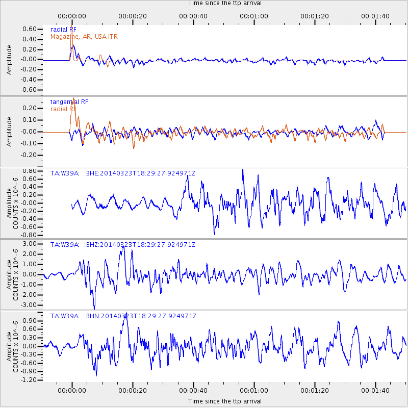
Signal To Noise
| Channel | StoN | STA | LTA |
| TA:W39A: :BHZ:20140323T18:29:27.924971Z | 2.7915738 | 6.7163325E-7 | 2.4059307E-7 |
| TA:W39A: :BHN:20140323T18:29:27.924971Z | 1.5894364 | 2.1560474E-7 | 1.3564855E-7 |
| TA:W39A: :BHE:20140323T18:29:27.924971Z | 1.6020336 | 1.8016613E-7 | 1.1246089E-7 |
| Arrivals |
| Ps | 2.2 SECOND |
| PpPs | 6.9 SECOND |
| PsPs/PpSs | 9.2 SECOND |


