You are here: Home > Network List > TA - USArray Transportable Network (new EarthScope stations) Stations List
> Station Y55A Saluda, SC, USA > Earthquake Result Viewer
Y55A Saluda, SC, USA - Earthquake Result Viewer
| Earthquake location: |
Near Coast Of Northern Chile |
| Earthquake latitude/longitude: |
-19.7/-70.8 |
| Earthquake time(UTC): |
2014/03/23 (082) 18:20:03 GMT |
| Earthquake Depth: |
35 km |
| Earthquake Magnitude: |
6.0 MB, 6.2 MWB, 6.2 MWW, 6.3 MWC |
| Earthquake Catalog/Contributor: |
NEIC PDE/NEIC COMCAT |
|
| Network: |
TA USArray Transportable Network (new EarthScope stations) |
| Station: |
Y55A Saluda, SC, USA |
| Lat/Lon: |
33.94 N/81.86 W |
| Elevation: |
164 m |
|
| Distance: |
54.4 deg |
| Az: |
348.703 deg |
| Baz: |
167.176 deg |
| Ray Param: |
0.06540322 |
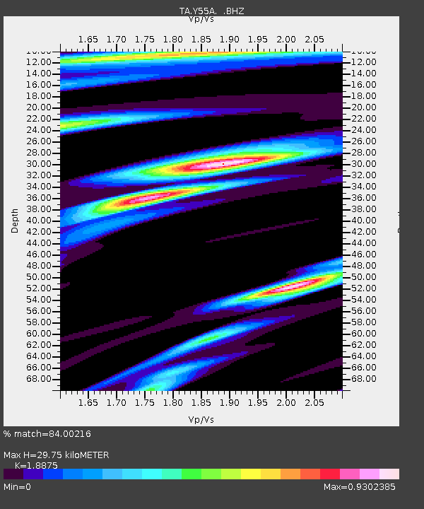
| Estimated Moho Depth: |
29.75 km |
| Estimated Crust Vp/Vs: |
1.89 |
| Assumed Crust Vp: |
6.565 km/s |
| Estimated Crust Vs: |
3.478 km/s |
| Estimated Crust Poisson's Ratio: |
0.30 |
|
| Radial Match: |
84.00216 % |
| Radial Bump: |
400 |
| Transverse Match: |
57.91526 % |
| Transverse Bump: |
400 |
| SOD ConfigId: |
626651 |
| Insert Time: |
2014-04-21 12:10:36.367 +0000 |
| GWidth: |
2.5 |
| Max Bumps: |
400 |
| Tol: |
0.001 |
|
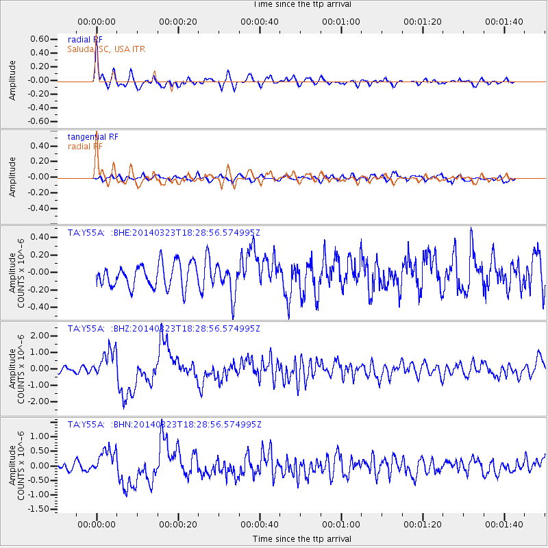
Signal To Noise
| Channel | StoN | STA | LTA |
| TA:Y55A: :BHZ:20140323T18:28:56.574995Z | 7.014341 | 9.010554E-7 | 1.2845902E-7 |
| TA:Y55A: :BHN:20140323T18:28:56.574995Z | 3.7283063 | 4.6466786E-7 | 1.2463242E-7 |
| TA:Y55A: :BHE:20140323T18:28:56.574995Z | 1.3325258 | 1.7930037E-7 | 1.3455677E-7 |
| Arrivals |
| Ps | 4.2 SECOND |
| PpPs | 12 SECOND |
| PsPs/PpSs | 17 SECOND |


