You are here: Home > Network List > TA - USArray Transportable Network (new EarthScope stations) Stations List
> Station Z59A Georgetown, SC, USA > Earthquake Result Viewer
Z59A Georgetown, SC, USA - Earthquake Result Viewer
| Earthquake location: |
Near Coast Of Northern Chile |
| Earthquake latitude/longitude: |
-19.7/-70.8 |
| Earthquake time(UTC): |
2014/03/23 (082) 18:20:03 GMT |
| Earthquake Depth: |
35 km |
| Earthquake Magnitude: |
6.0 MB, 6.2 MWB, 6.2 MWW, 6.3 MWC |
| Earthquake Catalog/Contributor: |
NEIC PDE/NEIC COMCAT |
|
| Network: |
TA USArray Transportable Network (new EarthScope stations) |
| Station: |
Z59A Georgetown, SC, USA |
| Lat/Lon: |
33.24 N/79.28 W |
| Elevation: |
8.0 m |
|
| Distance: |
53.3 deg |
| Az: |
351.147 deg |
| Baz: |
170.039 deg |
| Ray Param: |
0.0661222 |
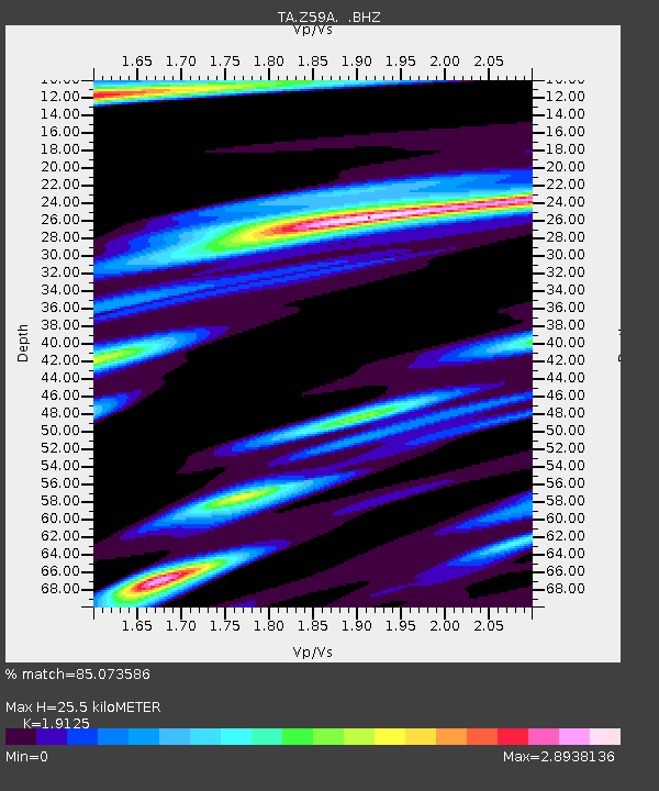
| Estimated Moho Depth: |
25.5 km |
| Estimated Crust Vp/Vs: |
1.91 |
| Assumed Crust Vp: |
6.24 km/s |
| Estimated Crust Vs: |
3.263 km/s |
| Estimated Crust Poisson's Ratio: |
0.31 |
|
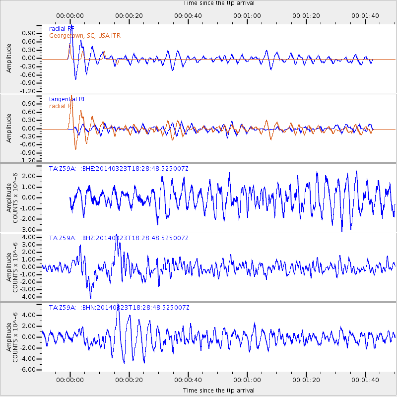
| Radial Match: |
85.073586 % |
| Radial Bump: |
400 |
| Transverse Match: |
57.999912 % |
| Transverse Bump: |
400 |
| SOD ConfigId: |
626651 |
| Insert Time: |
2014-04-21 12:11:04.739 +0000 |
| GWidth: |
2.5 |
| Max Bumps: |
400 |
| Tol: |
0.001 |
|
Signal To Noise
| Channel | StoN | STA | LTA |
| TA:Z59A: :BHZ:20140323T18:28:48.525007Z | 2.5265806 | 1.1368306E-6 | 4.499483E-7 |
| TA:Z59A: :BHN:20140323T18:28:48.525007Z | 0.8096232 | 9.300579E-7 | 1.1487541E-6 |
| TA:Z59A: :BHE:20140323T18:28:48.525007Z | 2.3710287 | 1.4446265E-6 | 6.092826E-7 |
| Arrivals |
| Ps | 3.9 SECOND |
| PpPs | 11 SECOND |
| PsPs/PpSs | 15 SECOND |


