You are here: Home > Network List > US - United States National Seismic Network Stations List
> Station DGMT Dagmar, Montana, USA > Earthquake Result Viewer
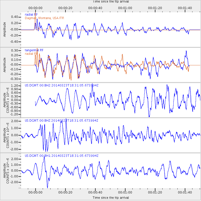
DGMT Dagmar, Montana, USA - Earthquake Result Viewer
*The percent match for this event was below the threshold and hence no stack was calculated.
| Earthquake location: |
Near Coast Of Northern Chile |
| Earthquake latitude/longitude: |
-19.7/-70.8 |
| Earthquake time(UTC): |
2014/03/23 (082) 18:20:03 GMT |
| Earthquake Depth: |
35 km |
| Earthquake Magnitude: |
6.0 MB, 6.2 MWB, 6.2 MWW, 6.3 MWC |
| Earthquake Catalog/Contributor: |
NEIC PDE/NEIC COMCAT |
|
| Network: |
US United States National Seismic Network |
| Station: |
DGMT Dagmar, Montana, USA |
| Lat/Lon: |
48.47 N/104.20 W |
| Elevation: |
0.0 m |
|
| Distance: |
74.2 deg |
| Az: |
337.627 deg |
| Baz: |
147.403 deg |
| Ray Param: |
$rayparam |
*The percent match for this event was below the threshold and hence was not used in the summary stack. |
|
| Radial Match: |
54.9748 % |
| Radial Bump: |
356 |
| Transverse Match: |
67.134834 % |
| Transverse Bump: |
368 |
| SOD ConfigId: |
626651 |
| Insert Time: |
2014-04-21 12:11:50.853 +0000 |
| GWidth: |
2.5 |
| Max Bumps: |
400 |
| Tol: |
0.001 |
|
Signal To Noise
| Channel | StoN | STA | LTA |
| US:DGMT:00:BHZ:20140323T18:31:05.673994Z | 2.776349 | 7.2269563E-7 | 2.6030432E-7 |
| US:DGMT:00:BH1:20140323T18:31:05.673994Z | 1.9703768 | 1.0108635E-6 | 5.1303056E-7 |
| US:DGMT:00:BH2:20140323T18:31:05.673994Z | 0.9968801 | 4.1463556E-7 | 4.1593321E-7 |
| Arrivals |
| Ps | |
| PpPs | |
| PsPs/PpSs | |


