You are here: Home > Network List > IU - Global Seismograph Network (GSN - IRIS/USGS) Stations List
> Station CTAO Charters Towers, Australia > Earthquake Result Viewer
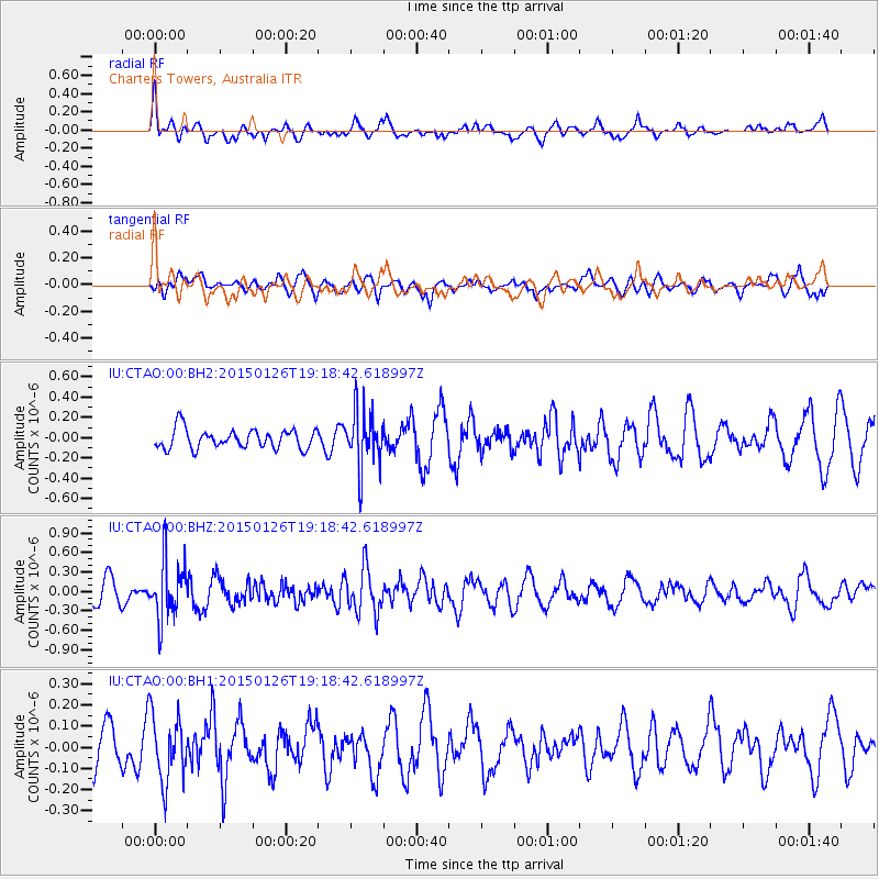
CTAO Charters Towers, Australia - Earthquake Result Viewer
*The percent match for this event was below the threshold and hence no stack was calculated.
| Earthquake location: |
Tonga Islands |
| Earthquake latitude/longitude: |
-18.8/-174.6 |
| Earthquake time(UTC): |
2015/01/26 (026) 19:12:13 GMT |
| Earthquake Depth: |
90 km |
| Earthquake Magnitude: |
5.3 MW, 5.2 mb |
| Earthquake Catalog/Contributor: |
ISC/ISC |
|
| Network: |
IU Global Seismograph Network (GSN - IRIS/USGS) |
| Station: |
CTAO Charters Towers, Australia |
| Lat/Lon: |
20.09 S/146.25 E |
| Elevation: |
357 m |
|
| Distance: |
36.9 deg |
| Az: |
261.425 deg |
| Baz: |
94.853 deg |
| Ray Param: |
$rayparam |
*The percent match for this event was below the threshold and hence was not used in the summary stack. |
|
| Radial Match: |
59.22858 % |
| Radial Bump: |
400 |
| Transverse Match: |
49.473866 % |
| Transverse Bump: |
400 |
| SOD ConfigId: |
3390531 |
| Insert Time: |
2019-04-16 04:21:37.222 +0000 |
| GWidth: |
2.5 |
| Max Bumps: |
400 |
| Tol: |
0.001 |
|
Signal To Noise
| Channel | StoN | STA | LTA |
| IU:CTAO:00:BHZ:20150126T19:18:42.618997Z | 2.5161722 | 4.536839E-7 | 1.8030718E-7 |
| IU:CTAO:00:BH1:20150126T19:18:42.618997Z | 1.1714454 | 1.5718605E-7 | 1.3418129E-7 |
| IU:CTAO:00:BH2:20150126T19:18:42.618997Z | 3.0028427 | 2.8374902E-7 | 9.4493465E-8 |
| Arrivals |
| Ps | |
| PpPs | |
| PsPs/PpSs | |


