You are here: Home > Network List > UW - Pacific Northwest Regional Seismic Network Stations List
> Station MRBL Marblemount, WA, USA > Earthquake Result Viewer
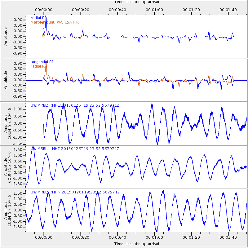
MRBL Marblemount, WA, USA - Earthquake Result Viewer
*The percent match for this event was below the threshold and hence no stack was calculated.
| Earthquake location: |
Tonga Islands |
| Earthquake latitude/longitude: |
-18.8/-174.6 |
| Earthquake time(UTC): |
2015/01/26 (026) 19:12:13 GMT |
| Earthquake Depth: |
90 km |
| Earthquake Magnitude: |
5.3 MW, 5.2 mb |
| Earthquake Catalog/Contributor: |
ISC/ISC |
|
| Network: |
UW Pacific Northwest Regional Seismic Network |
| Station: |
MRBL Marblemount, WA, USA |
| Lat/Lon: |
48.52 N/121.48 W |
| Elevation: |
75 m |
|
| Distance: |
82.1 deg |
| Az: |
32.481 deg |
| Baz: |
229.906 deg |
| Ray Param: |
$rayparam |
*The percent match for this event was below the threshold and hence was not used in the summary stack. |
|
| Radial Match: |
81.733025 % |
| Radial Bump: |
400 |
| Transverse Match: |
81.90745 % |
| Transverse Bump: |
354 |
| SOD ConfigId: |
3390531 |
| Insert Time: |
2019-04-16 04:24:57.124 +0000 |
| GWidth: |
2.5 |
| Max Bumps: |
400 |
| Tol: |
0.001 |
|
Signal To Noise
| Channel | StoN | STA | LTA |
| UW:MRBL: :HHZ:20150126T19:23:52.567971Z | 1.0050347 | 7.775766E-7 | 7.736814E-7 |
| UW:MRBL: :HHN:20150126T19:23:52.567971Z | 2.5157363 | 1.1498215E-6 | 4.570517E-7 |
| UW:MRBL: :HHE:20150126T19:23:52.567971Z | 1.0673671 | 8.596695E-7 | 8.0541133E-7 |
| Arrivals |
| Ps | |
| PpPs | |
| PsPs/PpSs | |


