You are here: Home > Network List > TA - USArray Transportable Network (new EarthScope stations) Stations List
> Station D51A Lot 18 Range III Mazenod Township, QC, CAN > Earthquake Result Viewer
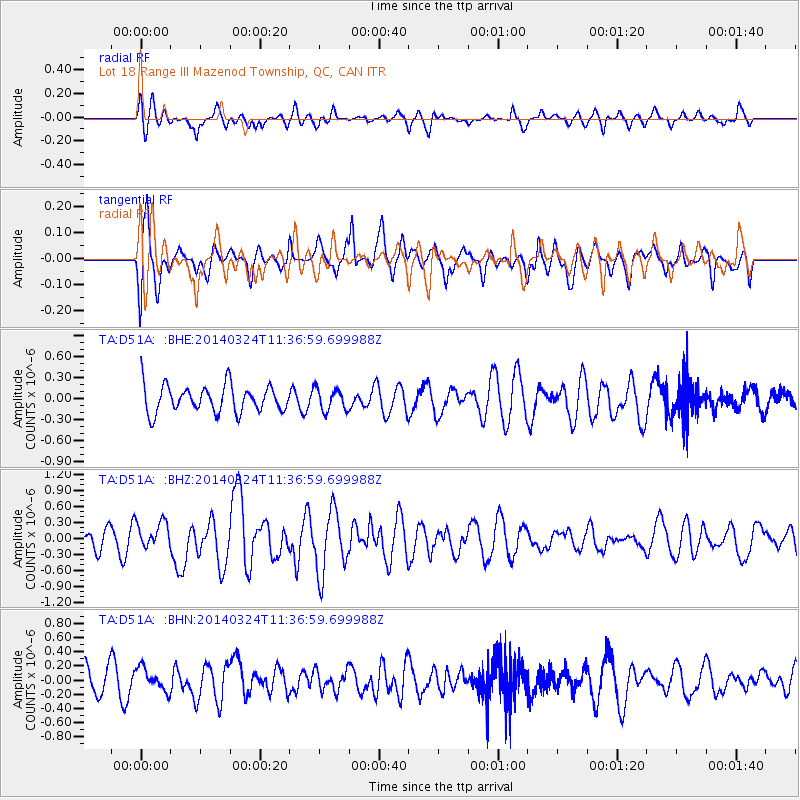
D51A Lot 18 Range III Mazenod Township, QC, CAN - Earthquake Result Viewer
*The percent match for this event was below the threshold and hence no stack was calculated.
| Earthquake location: |
Near Coast Of Northern Chile |
| Earthquake latitude/longitude: |
-19.8/-70.8 |
| Earthquake time(UTC): |
2014/03/24 (083) 11:26:39 GMT |
| Earthquake Depth: |
22 km |
| Earthquake Magnitude: |
5.7 MWW, 5.7 MWB, 5.8 MWC |
| Earthquake Catalog/Contributor: |
NEIC PDE/NEIC COMCAT |
|
| Network: |
TA USArray Transportable Network (new EarthScope stations) |
| Station: |
D51A Lot 18 Range III Mazenod Township, QC, CAN |
| Lat/Lon: |
47.09 N/79.37 W |
| Elevation: |
282 m |
|
| Distance: |
67.1 deg |
| Az: |
353.623 deg |
| Baz: |
171.198 deg |
| Ray Param: |
$rayparam |
*The percent match for this event was below the threshold and hence was not used in the summary stack. |
|
| Radial Match: |
54.293 % |
| Radial Bump: |
400 |
| Transverse Match: |
66.81639 % |
| Transverse Bump: |
400 |
| SOD ConfigId: |
626651 |
| Insert Time: |
2014-04-21 12:31:52.999 +0000 |
| GWidth: |
2.5 |
| Max Bumps: |
400 |
| Tol: |
0.001 |
|
Signal To Noise
| Channel | StoN | STA | LTA |
| TA:D51A: :BHZ:20140324T11:36:59.699988Z | 0.94585586 | 2.5473804E-7 | 2.6932014E-7 |
| TA:D51A: :BHN:20140324T11:36:59.699988Z | 0.7346783 | 1.6152615E-7 | 2.1985969E-7 |
| TA:D51A: :BHE:20140324T11:36:59.699988Z | 0.82021695 | 1.5802274E-7 | 1.9265968E-7 |
| Arrivals |
| Ps | |
| PpPs | |
| PsPs/PpSs | |


