You are here: Home > Network List > TA - USArray Transportable Network (new EarthScope stations) Stations List
> Station X43A Marvell, AR, USA > Earthquake Result Viewer
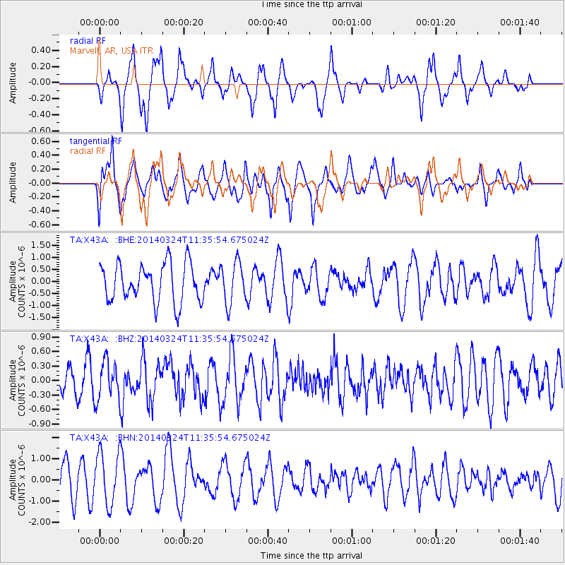
X43A Marvell, AR, USA - Earthquake Result Viewer
*The percent match for this event was below the threshold and hence no stack was calculated.
| Earthquake location: |
Near Coast Of Northern Chile |
| Earthquake latitude/longitude: |
-19.8/-70.8 |
| Earthquake time(UTC): |
2014/03/24 (083) 11:26:39 GMT |
| Earthquake Depth: |
22 km |
| Earthquake Magnitude: |
5.7 MWW, 5.7 MWB, 5.8 MWC |
| Earthquake Catalog/Contributor: |
NEIC PDE/NEIC COMCAT |
|
| Network: |
TA USArray Transportable Network (new EarthScope stations) |
| Station: |
X43A Marvell, AR, USA |
| Lat/Lon: |
34.52 N/90.88 W |
| Elevation: |
53 m |
|
| Distance: |
57.3 deg |
| Az: |
340.284 deg |
| Baz: |
157.378 deg |
| Ray Param: |
$rayparam |
*The percent match for this event was below the threshold and hence was not used in the summary stack. |
|
| Radial Match: |
46.476536 % |
| Radial Bump: |
314 |
| Transverse Match: |
52.738857 % |
| Transverse Bump: |
400 |
| SOD ConfigId: |
626651 |
| Insert Time: |
2014-04-21 12:37:40.759 +0000 |
| GWidth: |
2.5 |
| Max Bumps: |
400 |
| Tol: |
0.001 |
|
Signal To Noise
| Channel | StoN | STA | LTA |
| TA:X43A: :BHZ:20140324T11:35:54.675024Z | 1.361795 | 3.957216E-7 | 2.9058825E-7 |
| TA:X43A: :BHN:20140324T11:35:54.675024Z | 2.0014184 | 1.2679316E-6 | 6.335165E-7 |
| TA:X43A: :BHE:20140324T11:35:54.675024Z | 1.1044163 | 8.762069E-7 | 7.9336655E-7 |
| Arrivals |
| Ps | |
| PpPs | |
| PsPs/PpSs | |


