You are here: Home > Network List > XL12 - Hangay Dome, Mongolia Stations List
> Station AT01 AT01 > Earthquake Result Viewer
AT01 AT01 - Earthquake Result Viewer
| Earthquake location: |
Northern Sumatra, Indonesia |
| Earthquake latitude/longitude: |
1.4/97.2 |
| Earthquake time(UTC): |
2015/01/27 (027) 00:53:19 GMT |
| Earthquake Depth: |
13 km |
| Earthquake Magnitude: |
5.6 MB, 5.7 MWB |
| Earthquake Catalog/Contributor: |
NEIC PDE/NEIC COMCAT |
|
| Network: |
XL Hangay Dome, Mongolia |
| Station: |
AT01 AT01 |
| Lat/Lon: |
45.36 N/93.62 E |
| Elevation: |
1561 m |
|
| Distance: |
43.9 deg |
| Az: |
356.334 deg |
| Baz: |
174.798 deg |
| Ray Param: |
0.07223233 |
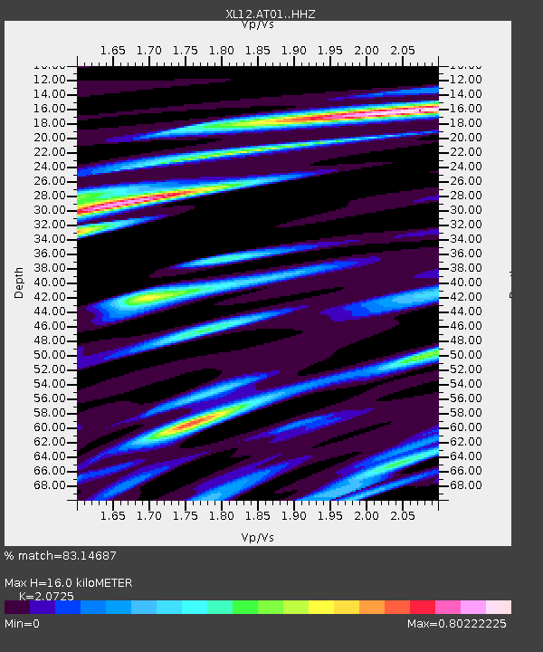
| Estimated Moho Depth: |
16.0 km |
| Estimated Crust Vp/Vs: |
2.07 |
| Assumed Crust Vp: |
6.353 km/s |
| Estimated Crust Vs: |
3.065 km/s |
| Estimated Crust Poisson's Ratio: |
0.35 |
|
| Radial Match: |
83.14687 % |
| Radial Bump: |
400 |
| Transverse Match: |
58.74251 % |
| Transverse Bump: |
400 |
| SOD ConfigId: |
3390531 |
| Insert Time: |
2019-04-16 04:30:26.813 +0000 |
| GWidth: |
2.5 |
| Max Bumps: |
400 |
| Tol: |
0.001 |
|

Signal To Noise
| Channel | StoN | STA | LTA |
| XL:AT01: :HHZ:20150127T01:00:55.779987Z | 6.717291 | 5.025265E-7 | 7.4810885E-8 |
| XL:AT01: :HHN:20150127T01:00:55.779987Z | 4.6913767 | 3.1784148E-7 | 6.775016E-8 |
| XL:AT01: :HHE:20150127T01:00:55.779987Z | 1.2781823 | 8.7404736E-8 | 6.8382064E-8 |
| Arrivals |
| Ps | 2.9 SECOND |
| PpPs | 7.3 SECOND |
| PsPs/PpSs | 10 SECOND |


