You are here: Home > Network List > TA - USArray Transportable Network (new EarthScope stations) Stations List
> Station U59A Littleton, NC, USA > Earthquake Result Viewer
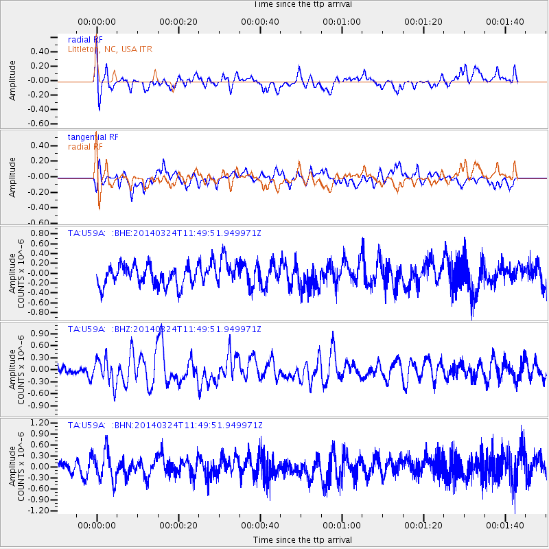
U59A Littleton, NC, USA - Earthquake Result Viewer
*The percent match for this event was below the threshold and hence no stack was calculated.
| Earthquake location: |
Near Coast Of Northern Chile |
| Earthquake latitude/longitude: |
-19.8/-70.8 |
| Earthquake time(UTC): |
2014/03/24 (083) 11:40:44 GMT |
| Earthquake Depth: |
23 km |
| Earthquake Magnitude: |
5.5 MB, 5.5 MWR, 5.6 MWW, 5.7 MWC |
| Earthquake Catalog/Contributor: |
NEIC PDE/NEIC COMCAT |
|
| Network: |
TA USArray Transportable Network (new EarthScope stations) |
| Station: |
U59A Littleton, NC, USA |
| Lat/Lon: |
36.35 N/77.79 W |
| Elevation: |
99 m |
|
| Distance: |
56.2 deg |
| Az: |
353.242 deg |
| Baz: |
172.111 deg |
| Ray Param: |
$rayparam |
*The percent match for this event was below the threshold and hence was not used in the summary stack. |
|
| Radial Match: |
63.97346 % |
| Radial Bump: |
400 |
| Transverse Match: |
61.751236 % |
| Transverse Bump: |
400 |
| SOD ConfigId: |
626651 |
| Insert Time: |
2014-04-21 13:00:09.078 +0000 |
| GWidth: |
2.5 |
| Max Bumps: |
400 |
| Tol: |
0.001 |
|
Signal To Noise
| Channel | StoN | STA | LTA |
| TA:U59A: :BHZ:20140324T11:49:51.949971Z | 1.6154633 | 3.2229394E-7 | 1.9950559E-7 |
| TA:U59A: :BHN:20140324T11:49:51.949971Z | 2.4973233 | 4.1851618E-7 | 1.6758591E-7 |
| TA:U59A: :BHE:20140324T11:49:51.949971Z | 1.4570205 | 2.9084745E-7 | 1.9961796E-7 |
| Arrivals |
| Ps | |
| PpPs | |
| PsPs/PpSs | |


