You are here: Home > Network List > TA - USArray Transportable Network (new EarthScope stations) Stations List
> Station W56A Indian Trail, NC, USA > Earthquake Result Viewer
W56A Indian Trail, NC, USA - Earthquake Result Viewer
*The percent match for this event was below the threshold and hence no stack was calculated.
| Earthquake location: |
Near Coast Of Northern Chile |
| Earthquake latitude/longitude: |
-19.8/-70.8 |
| Earthquake time(UTC): |
2014/03/24 (083) 11:40:44 GMT |
| Earthquake Depth: |
23 km |
| Earthquake Magnitude: |
5.5 MB, 5.5 MWR, 5.6 MWW, 5.7 MWC |
| Earthquake Catalog/Contributor: |
NEIC PDE/NEIC COMCAT |
|
| Network: |
TA USArray Transportable Network (new EarthScope stations) |
| Station: |
W56A Indian Trail, NC, USA |
| Lat/Lon: |
35.13 N/80.58 W |
| Elevation: |
177 m |
|
| Distance: |
55.4 deg |
| Az: |
350.293 deg |
| Baz: |
168.831 deg |
| Ray Param: |
$rayparam |
*The percent match for this event was below the threshold and hence was not used in the summary stack. |
|
| Radial Match: |
63.091095 % |
| Radial Bump: |
400 |
| Transverse Match: |
62.564552 % |
| Transverse Bump: |
400 |
| SOD ConfigId: |
626651 |
| Insert Time: |
2014-04-21 13:00:27.556 +0000 |
| GWidth: |
2.5 |
| Max Bumps: |
400 |
| Tol: |
0.001 |
|
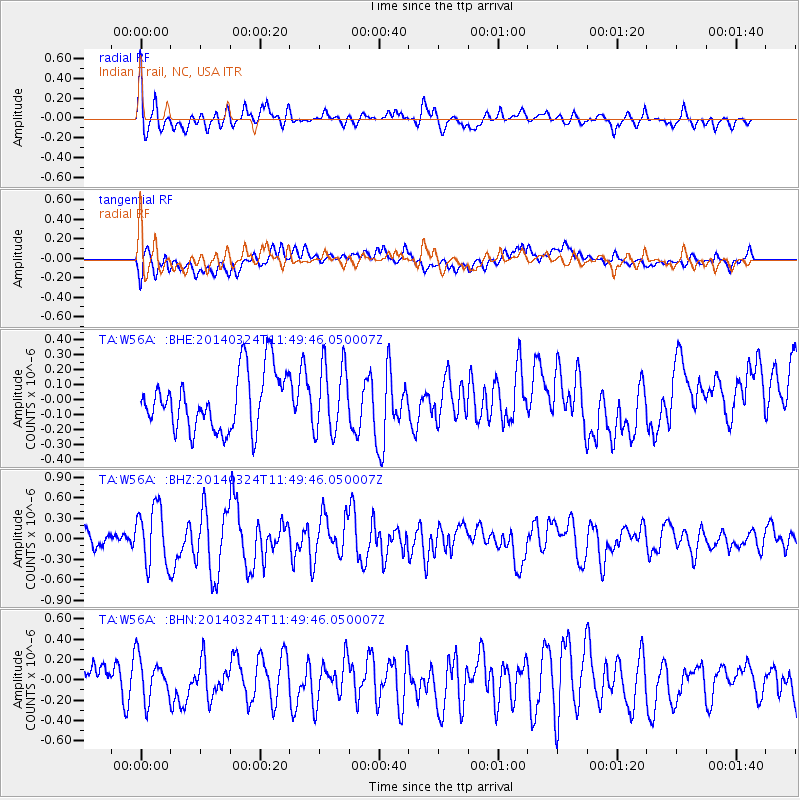
Signal To Noise
| Channel | StoN | STA | LTA |
| TA:W56A: :BHZ:20140324T11:49:46.050007Z | 2.6264198 | 4.2899637E-7 | 1.6333885E-7 |
| TA:W56A: :BHN:20140324T11:49:46.050007Z | 1.031886 | 2.0604595E-7 | 1.99679E-7 |
| TA:W56A: :BHE:20140324T11:49:46.050007Z | 1.2021592 | 2.2903275E-7 | 1.9051782E-7 |
| Arrivals |
| Ps | |
| PpPs | |
| PsPs/PpSs | |


