You are here: Home > Network List > TA - USArray Transportable Network (new EarthScope stations) Stations List
> Station W56A Indian Trail, NC, USA > Earthquake Result Viewer
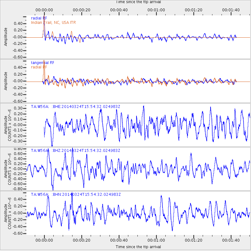
W56A Indian Trail, NC, USA - Earthquake Result Viewer
*The percent match for this event was below the threshold and hence no stack was calculated.
| Earthquake location: |
Near Coast Of Northern Chile |
| Earthquake latitude/longitude: |
-19.6/-70.8 |
| Earthquake time(UTC): |
2014/03/24 (083) 15:45:31 GMT |
| Earthquake Depth: |
18 km |
| Earthquake Magnitude: |
5.6 MWB, 5.5 MWR, 5.7 MWC, 5.7 MWW |
| Earthquake Catalog/Contributor: |
NEIC PDE/NEIC COMCAT |
|
| Network: |
TA USArray Transportable Network (new EarthScope stations) |
| Station: |
W56A Indian Trail, NC, USA |
| Lat/Lon: |
35.13 N/80.58 W |
| Elevation: |
177 m |
|
| Distance: |
55.2 deg |
| Az: |
350.255 deg |
| Baz: |
168.773 deg |
| Ray Param: |
$rayparam |
*The percent match for this event was below the threshold and hence was not used in the summary stack. |
|
| Radial Match: |
68.05181 % |
| Radial Bump: |
400 |
| Transverse Match: |
46.666508 % |
| Transverse Bump: |
400 |
| SOD ConfigId: |
626651 |
| Insert Time: |
2014-04-21 13:28:05.183 +0000 |
| GWidth: |
2.5 |
| Max Bumps: |
400 |
| Tol: |
0.001 |
|
Signal To Noise
| Channel | StoN | STA | LTA |
| TA:W56A: :BHZ:20140324T15:54:32.024983Z | 2.5867589 | 4.390465E-7 | 1.6972842E-7 |
| TA:W56A: :BHN:20140324T15:54:32.024983Z | 2.387589 | 2.5723241E-7 | 1.077373E-7 |
| TA:W56A: :BHE:20140324T15:54:32.024983Z | 1.6673071 | 1.7909169E-7 | 1.0741373E-7 |
| Arrivals |
| Ps | |
| PpPs | |
| PsPs/PpSs | |


