You are here: Home > Network List > 1U - Mt. Paektu Seismic Network Stations List
> Station JGPD Jang Gun Peak > Earthquake Result Viewer
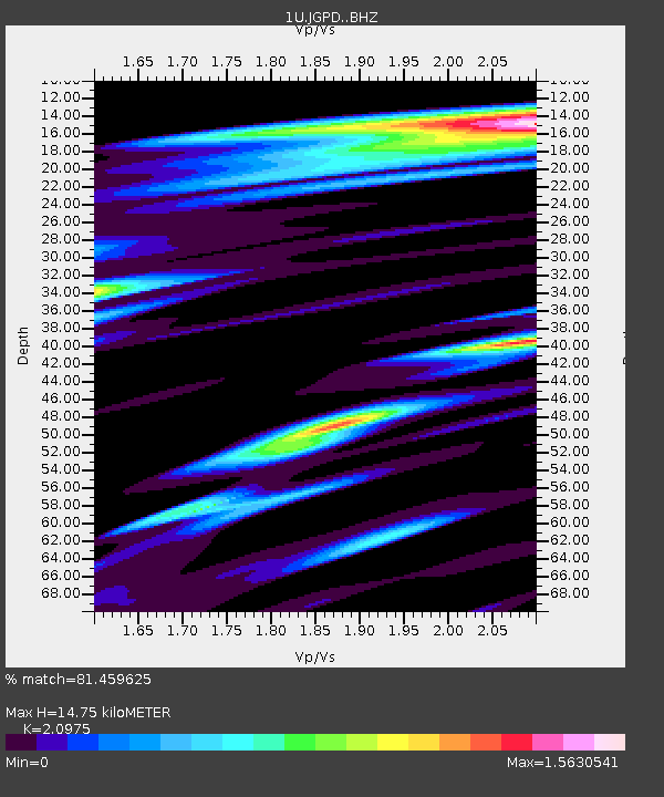
JGPD Jang Gun Peak - Earthquake Result Viewer
| Earthquake location: |
Fiji Islands Region |
| Earthquake latitude/longitude: |
-20.9/-178.4 |
| Earthquake time(UTC): |
2015/01/28 (028) 02:43:19 GMT |
| Earthquake Depth: |
484 km |
| Earthquake Magnitude: |
6.1 MWP |
| Earthquake Catalog/Contributor: |
NEIC PDE/NEIC COMCAT |
|
| Network: |
1U Mt. Paektu Seismic Network |
| Station: |
JGPD Jang Gun Peak |
| Lat/Lon: |
41.99 N/128.08 E |
| Elevation: |
2648 m |
|
| Distance: |
79.8 deg |
| Az: |
322.454 deg |
| Baz: |
130.153 deg |
| Ray Param: |
0.047312733 |
| Estimated Moho Depth: |
14.75 km |
| Estimated Crust Vp/Vs: |
2.10 |
| Assumed Crust Vp: |
6.472 km/s |
| Estimated Crust Vs: |
3.086 km/s |
| Estimated Crust Poisson's Ratio: |
0.35 |
|
| Radial Match: |
81.459625 % |
| Radial Bump: |
345 |
| Transverse Match: |
67.38379 % |
| Transverse Bump: |
400 |
| SOD ConfigId: |
3390531 |
| Insert Time: |
2019-04-16 04:37:05.893 +0000 |
| GWidth: |
2.5 |
| Max Bumps: |
400 |
| Tol: |
0.001 |
|

Signal To Noise
| Channel | StoN | STA | LTA |
| 1U:JGPD: :BHZ:20150128T02:54:05.740027Z | 15.982931 | 3.4415075E-6 | 2.1532392E-7 |
| 1U:JGPD: :BHN:20150128T02:54:05.740027Z | 1.7977164 | 1.1041335E-6 | 6.1418666E-7 |
| 1U:JGPD: :BHE:20150128T02:54:05.740027Z | 2.3587818 | 1.7422041E-6 | 7.3860326E-7 |
| Arrivals |
| Ps | 2.6 SECOND |
| PpPs | 6.9 SECOND |
| PsPs/PpSs | 9.5 SECOND |


