You are here: Home > Network List > G - GEOSCOPE Stations List
> Station INU Inuyama, Japan > Earthquake Result Viewer
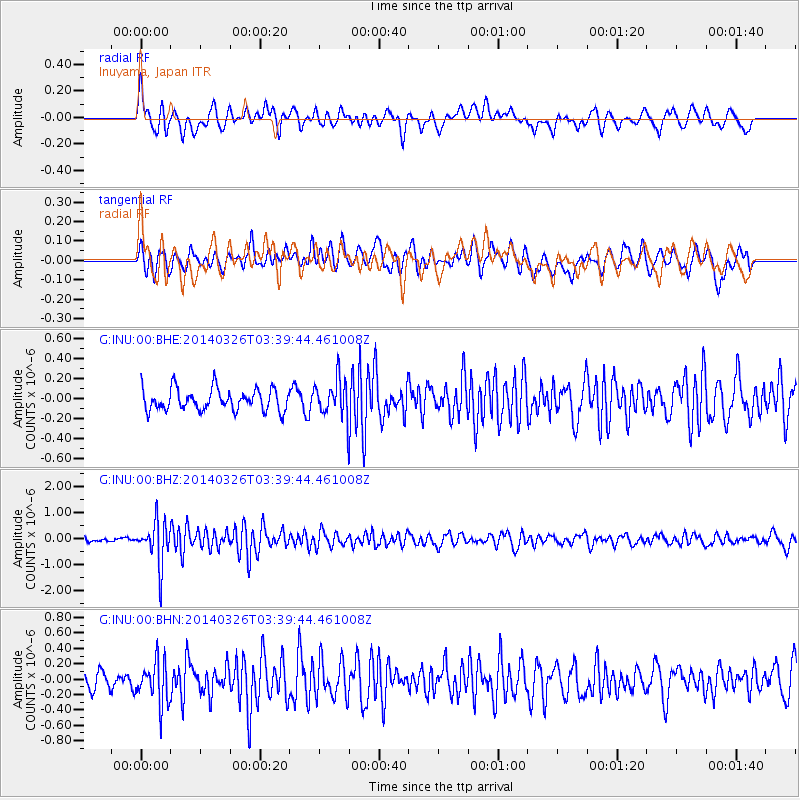
INU Inuyama, Japan - Earthquake Result Viewer
*The percent match for this event was below the threshold and hence no stack was calculated.
| Earthquake location: |
South Of Fiji Islands |
| Earthquake latitude/longitude: |
-26.1/179.3 |
| Earthquake time(UTC): |
2014/03/26 (085) 03:29:36 GMT |
| Earthquake Depth: |
493 km |
| Earthquake Magnitude: |
6.5 MWP, 6.3 MWW, 6.3 MWC, 6.4 MWB, 6.4 MWC, 6.5 MI |
| Earthquake Catalog/Contributor: |
NEIC PDE/NEIC COMCAT |
|
| Network: |
G GEOSCOPE |
| Station: |
INU Inuyama, Japan |
| Lat/Lon: |
35.35 N/137.03 E |
| Elevation: |
132 m |
|
| Distance: |
73.0 deg |
| Az: |
324.921 deg |
| Baz: |
140.786 deg |
| Ray Param: |
$rayparam |
*The percent match for this event was below the threshold and hence was not used in the summary stack. |
|
| Radial Match: |
67.44439 % |
| Radial Bump: |
400 |
| Transverse Match: |
58.857796 % |
| Transverse Bump: |
400 |
| SOD ConfigId: |
626651 |
| Insert Time: |
2014-04-21 13:42:47.254 +0000 |
| GWidth: |
2.5 |
| Max Bumps: |
400 |
| Tol: |
0.001 |
|
Signal To Noise
| Channel | StoN | STA | LTA |
| G:INU:00:BHZ:20140326T03:39:44.461008Z | 8.17292 | 8.1601564E-7 | 9.984383E-8 |
| G:INU:00:BHN:20140326T03:39:44.461008Z | 1.9710052 | 2.8078202E-7 | 1.4245624E-7 |
| G:INU:00:BHE:20140326T03:39:44.461008Z | 1.6996782 | 1.8438611E-7 | 1.0848296E-7 |
| Arrivals |
| Ps | |
| PpPs | |
| PsPs/PpSs | |


