You are here: Home > Network List > G - GEOSCOPE Stations List
> Station TAOE Taiohae, Marquises islands > Earthquake Result Viewer
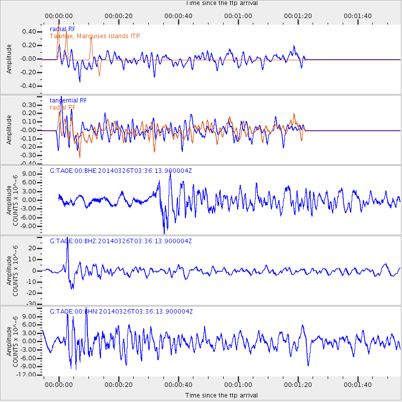
TAOE Taiohae, Marquises islands - Earthquake Result Viewer
*The percent match for this event was below the threshold and hence no stack was calculated.
| Earthquake location: |
South Of Fiji Islands |
| Earthquake latitude/longitude: |
-26.1/179.3 |
| Earthquake time(UTC): |
2014/03/26 (085) 03:29:36 GMT |
| Earthquake Depth: |
493 km |
| Earthquake Magnitude: |
6.5 MWP, 6.3 MWW, 6.3 MWC, 6.4 MWB, 6.4 MWC, 6.5 MI |
| Earthquake Catalog/Contributor: |
NEIC PDE/NEIC COMCAT |
|
| Network: |
G GEOSCOPE |
| Station: |
TAOE Taiohae, Marquises islands |
| Lat/Lon: |
8.85 S/140.15 W |
| Elevation: |
800 m |
|
| Distance: |
42.1 deg |
| Az: |
73.465 deg |
| Baz: |
240.73 deg |
| Ray Param: |
$rayparam |
*The percent match for this event was below the threshold and hence was not used in the summary stack. |
|
| Radial Match: |
48.64324 % |
| Radial Bump: |
400 |
| Transverse Match: |
58.529106 % |
| Transverse Bump: |
400 |
| SOD ConfigId: |
626651 |
| Insert Time: |
2014-04-21 13:42:54.064 +0000 |
| GWidth: |
2.5 |
| Max Bumps: |
400 |
| Tol: |
0.001 |
|
Signal To Noise
| Channel | StoN | STA | LTA |
| G:TAOE:00:BHZ:20140326T03:36:13.900004Z | 5.610549 | 1.0152423E-5 | 1.809524E-6 |
| G:TAOE:00:BHN:20140326T03:36:13.900004Z | 1.3515017 | 4.272433E-6 | 3.1612487E-6 |
| G:TAOE:00:BHE:20140326T03:36:13.900004Z | 2.3361585 | 2.8316547E-6 | 1.2120987E-6 |
| Arrivals |
| Ps | |
| PpPs | |
| PsPs/PpSs | |


