You are here: Home > Network List > II - Global Seismograph Network (GSN - IRIS/IDA) Stations List
> Station XPFO Pinon Flat, California, USA > Earthquake Result Viewer
XPFO Pinon Flat, California, USA - Earthquake Result Viewer
| Earthquake location: |
South Of Fiji Islands |
| Earthquake latitude/longitude: |
-26.1/179.3 |
| Earthquake time(UTC): |
2014/03/26 (085) 03:29:36 GMT |
| Earthquake Depth: |
493 km |
| Earthquake Magnitude: |
6.5 MWP, 6.3 MWW, 6.3 MWC, 6.4 MWB, 6.4 MWC, 6.5 MI |
| Earthquake Catalog/Contributor: |
NEIC PDE/NEIC COMCAT |
|
| Network: |
II Global Seismograph Network (GSN - IRIS/IDA) |
| Station: |
XPFO Pinon Flat, California, USA |
| Lat/Lon: |
33.61 N/116.46 W |
| Elevation: |
1280 m |
|
| Distance: |
85.1 deg |
| Az: |
48.98 deg |
| Baz: |
234.39 deg |
| Ray Param: |
0.04361306 |
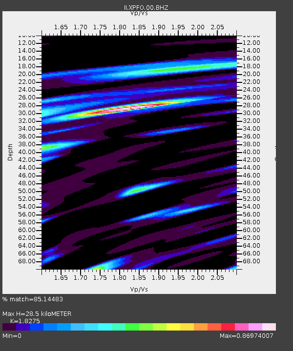
| Estimated Moho Depth: |
28.5 km |
| Estimated Crust Vp/Vs: |
1.83 |
| Assumed Crust Vp: |
6.264 km/s |
| Estimated Crust Vs: |
3.427 km/s |
| Estimated Crust Poisson's Ratio: |
0.29 |
|
| Radial Match: |
85.14483 % |
| Radial Bump: |
400 |
| Transverse Match: |
80.18773 % |
| Transverse Bump: |
400 |
| SOD ConfigId: |
626651 |
| Insert Time: |
2014-04-21 13:44:53.934 +0000 |
| GWidth: |
2.5 |
| Max Bumps: |
400 |
| Tol: |
0.001 |
|

Signal To Noise
| Channel | StoN | STA | LTA |
| II:XPFO:00:BHZ:20140326T03:40:48.619028Z | 18.336561 | 3.4526208E-6 | 1.8829162E-7 |
| II:XPFO:00:BH1:20140326T03:40:48.619028Z | 2.6500196 | 5.162578E-7 | 1.9481283E-7 |
| II:XPFO:00:BH2:20140326T03:40:48.619028Z | 5.278577 | 8.3419025E-7 | 1.5803316E-7 |
| Arrivals |
| Ps | 3.8 SECOND |
| PpPs | 13 SECOND |
| PsPs/PpSs | 16 SECOND |


