You are here: Home > Network List > AZ - ANZA Regional Network Stations List
> Station SMER AZ.SMER > Earthquake Result Viewer
SMER AZ.SMER - Earthquake Result Viewer
*The percent match for this event was below the threshold and hence no stack was calculated.
| Earthquake location: |
Fiji Islands Region |
| Earthquake latitude/longitude: |
-20.9/-178.4 |
| Earthquake time(UTC): |
2015/01/28 (028) 02:43:19 GMT |
| Earthquake Depth: |
484 km |
| Earthquake Magnitude: |
6.1 MWP |
| Earthquake Catalog/Contributor: |
NEIC PDE/NEIC COMCAT |
|
| Network: |
AZ ANZA Regional Network |
| Station: |
SMER AZ.SMER |
| Lat/Lon: |
33.46 N/117.17 W |
| Elevation: |
355 m |
|
| Distance: |
79.5 deg |
| Az: |
48.151 deg |
| Baz: |
236.417 deg |
| Ray Param: |
$rayparam |
*The percent match for this event was below the threshold and hence was not used in the summary stack. |
|
| Radial Match: |
66.63979 % |
| Radial Bump: |
400 |
| Transverse Match: |
72.87259 % |
| Transverse Bump: |
400 |
| SOD ConfigId: |
3390531 |
| Insert Time: |
2019-04-16 04:39:08.499 +0000 |
| GWidth: |
2.5 |
| Max Bumps: |
400 |
| Tol: |
0.001 |
|
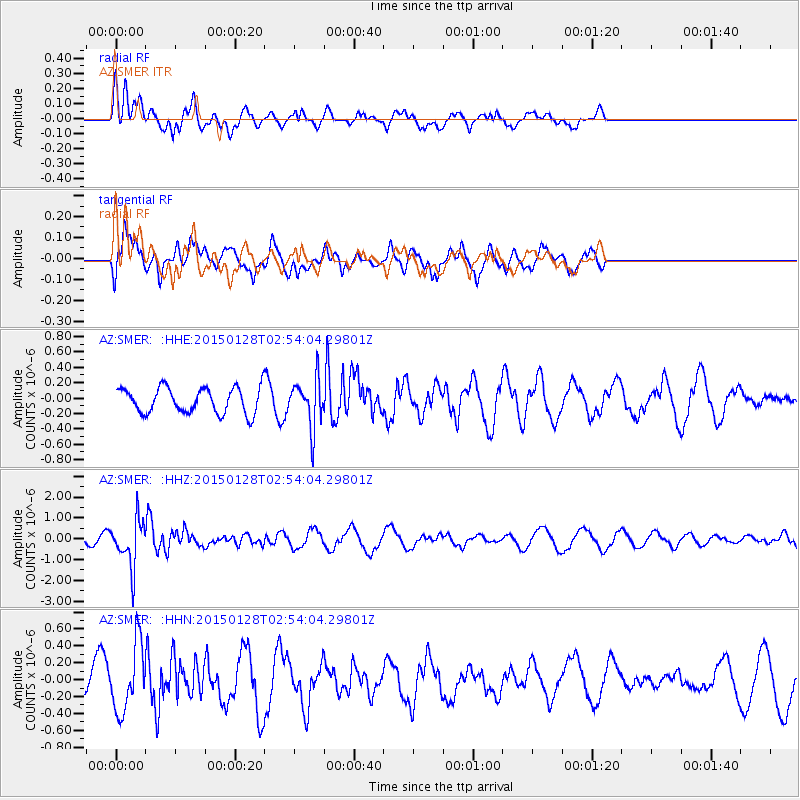
Signal To Noise
| Channel | StoN | STA | LTA |
| AZ:SMER: :HHZ:20150128T02:54:04.29801Z | 5.424881 | 1.1324331E-6 | 2.08748E-7 |
| AZ:SMER: :HHN:20150128T02:54:04.29801Z | 2.5557728 | 4.016018E-7 | 1.5713516E-7 |
| AZ:SMER: :HHE:20150128T02:54:04.29801Z | 1.8625003 | 3.16594E-7 | 1.6998332E-7 |
| Arrivals |
| Ps | |
| PpPs | |
| PsPs/PpSs | |


