You are here: Home > Network List > TA - USArray Transportable Network (new EarthScope stations) Stations List
> Station L04D Klamath Falls, OR, USA > Earthquake Result Viewer
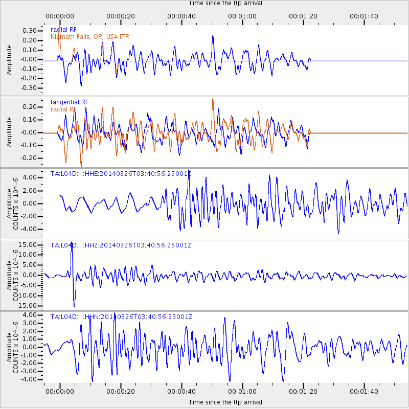
L04D Klamath Falls, OR, USA - Earthquake Result Viewer
*The percent match for this event was below the threshold and hence no stack was calculated.
| Earthquake location: |
South Of Fiji Islands |
| Earthquake latitude/longitude: |
-26.1/179.3 |
| Earthquake time(UTC): |
2014/03/26 (085) 03:29:36 GMT |
| Earthquake Depth: |
493 km |
| Earthquake Magnitude: |
6.5 MWP, 6.3 MWW, 6.3 MWC, 6.4 MWB, 6.4 MWC, 6.5 MI |
| Earthquake Catalog/Contributor: |
NEIC PDE/NEIC COMCAT |
|
| Network: |
TA USArray Transportable Network (new EarthScope stations) |
| Station: |
L04D Klamath Falls, OR, USA |
| Lat/Lon: |
42.22 N/122.30 W |
| Elevation: |
1437 m |
|
| Distance: |
86.7 deg |
| Az: |
39.334 deg |
| Baz: |
230.112 deg |
| Ray Param: |
$rayparam |
*The percent match for this event was below the threshold and hence was not used in the summary stack. |
|
| Radial Match: |
73.69297 % |
| Radial Bump: |
400 |
| Transverse Match: |
68.01793 % |
| Transverse Bump: |
312 |
| SOD ConfigId: |
626651 |
| Insert Time: |
2014-04-21 13:51:29.509 +0000 |
| GWidth: |
2.5 |
| Max Bumps: |
400 |
| Tol: |
0.001 |
|
Signal To Noise
| Channel | StoN | STA | LTA |
| TA:L04D: :HHZ:20140326T03:40:56.25001Z | 12.900243 | 5.937843E-6 | 4.6028924E-7 |
| TA:L04D: :HHN:20140326T03:40:56.25001Z | 1.2011282 | 6.0301466E-7 | 5.020402E-7 |
| TA:L04D: :HHE:20140326T03:40:56.25001Z | 0.919171 | 7.392476E-7 | 8.042547E-7 |
| Arrivals |
| Ps | |
| PpPs | |
| PsPs/PpSs | |


