You are here: Home > Network List > TA - USArray Transportable Network (new EarthScope stations) Stations List
> Station MSTX Muleshoe, TX, USA > Earthquake Result Viewer
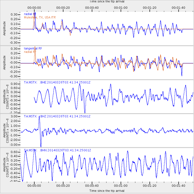
MSTX Muleshoe, TX, USA - Earthquake Result Viewer
*The percent match for this event was below the threshold and hence no stack was calculated.
| Earthquake location: |
South Of Fiji Islands |
| Earthquake latitude/longitude: |
-26.1/179.3 |
| Earthquake time(UTC): |
2014/03/26 (085) 03:29:36 GMT |
| Earthquake Depth: |
493 km |
| Earthquake Magnitude: |
6.5 MWP, 6.3 MWW, 6.3 MWC, 6.4 MWB, 6.4 MWC, 6.5 MI |
| Earthquake Catalog/Contributor: |
NEIC PDE/NEIC COMCAT |
|
| Network: |
TA USArray Transportable Network (new EarthScope stations) |
| Station: |
MSTX Muleshoe, TX, USA |
| Lat/Lon: |
33.97 N/102.77 W |
| Elevation: |
1167 m |
|
| Distance: |
95.0 deg |
| Az: |
54.673 deg |
| Baz: |
241.982 deg |
| Ray Param: |
$rayparam |
*The percent match for this event was below the threshold and hence was not used in the summary stack. |
|
| Radial Match: |
51.771507 % |
| Radial Bump: |
301 |
| Transverse Match: |
46.88975 % |
| Transverse Bump: |
349 |
| SOD ConfigId: |
626651 |
| Insert Time: |
2014-04-21 13:51:35.607 +0000 |
| GWidth: |
2.5 |
| Max Bumps: |
400 |
| Tol: |
0.001 |
|
Signal To Noise
| Channel | StoN | STA | LTA |
| TA:MSTX: :BHZ:20140326T03:41:34.25001Z | 5.7333083 | 1.4524226E-6 | 2.5333063E-7 |
| TA:MSTX: :BHN:20140326T03:41:34.25001Z | 0.90112627 | 3.7053059E-7 | 4.1118608E-7 |
| TA:MSTX: :BHE:20140326T03:41:34.25001Z | 1.5656581 | 5.845098E-7 | 3.7333166E-7 |
| Arrivals |
| Ps | |
| PpPs | |
| PsPs/PpSs | |


