You are here: Home > Network List > UU - University of Utah Regional Network Stations List
> Station CCUT Cedar City, UT, USA > Earthquake Result Viewer
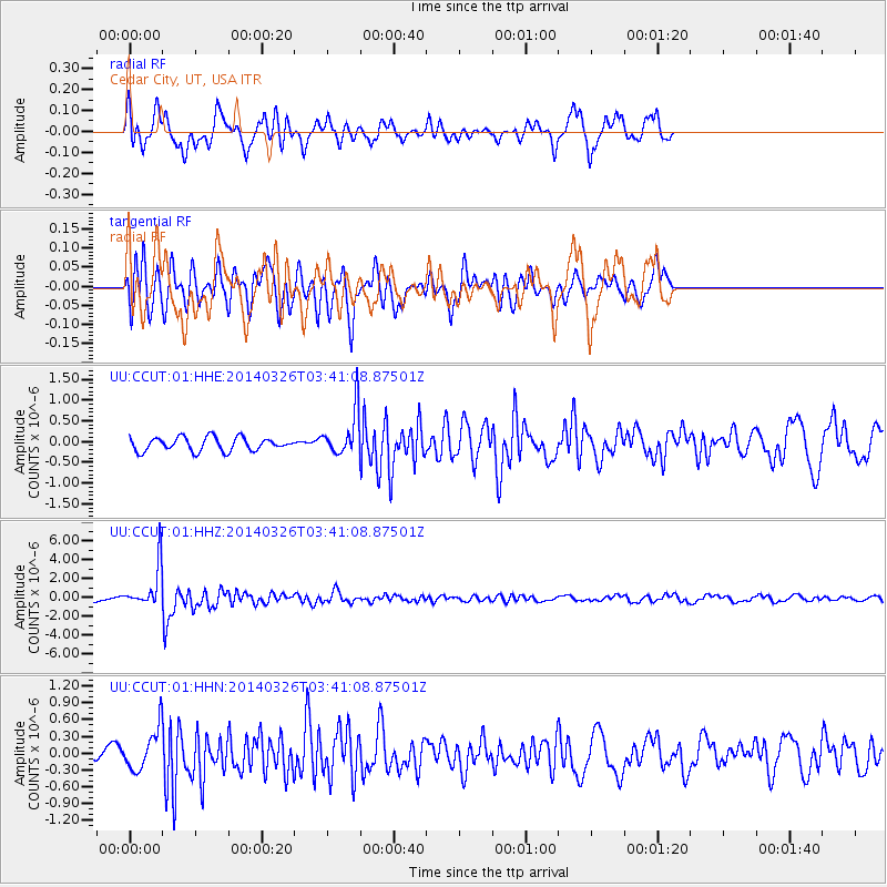
CCUT Cedar City, UT, USA - Earthquake Result Viewer
*The percent match for this event was below the threshold and hence no stack was calculated.
| Earthquake location: |
South Of Fiji Islands |
| Earthquake latitude/longitude: |
-26.1/179.3 |
| Earthquake time(UTC): |
2014/03/26 (085) 03:29:36 GMT |
| Earthquake Depth: |
493 km |
| Earthquake Magnitude: |
6.5 MWP, 6.3 MWW, 6.3 MWC, 6.4 MWB, 6.4 MWC, 6.5 MI |
| Earthquake Catalog/Contributor: |
NEIC PDE/NEIC COMCAT |
|
| Network: |
UU University of Utah Regional Network |
| Station: |
CCUT Cedar City, UT, USA |
| Lat/Lon: |
37.55 N/113.36 W |
| Elevation: |
2127 m |
|
| Distance: |
89.4 deg |
| Az: |
47.186 deg |
| Baz: |
236.098 deg |
| Ray Param: |
$rayparam |
*The percent match for this event was below the threshold and hence was not used in the summary stack. |
|
| Radial Match: |
68.02722 % |
| Radial Bump: |
289 |
| Transverse Match: |
68.56558 % |
| Transverse Bump: |
350 |
| SOD ConfigId: |
626651 |
| Insert Time: |
2014-04-21 13:53:38.592 +0000 |
| GWidth: |
2.5 |
| Max Bumps: |
400 |
| Tol: |
0.001 |
|
Signal To Noise
| Channel | StoN | STA | LTA |
| UU:CCUT:01:HHZ:20140326T03:41:08.87501Z | 10.617366 | 2.208262E-6 | 2.0798586E-7 |
| UU:CCUT:01:HHN:20140326T03:41:08.87501Z | 2.5609987 | 3.5499298E-7 | 1.3861505E-7 |
| UU:CCUT:01:HHE:20140326T03:41:08.87501Z | 3.262256 | 5.317925E-7 | 1.6301374E-7 |
| Arrivals |
| Ps | |
| PpPs | |
| PsPs/PpSs | |


