You are here: Home > Network List > CI - Caltech Regional Seismic Network Stations List
> Station GLA Glamis, Glamis, CA, USA > Earthquake Result Viewer
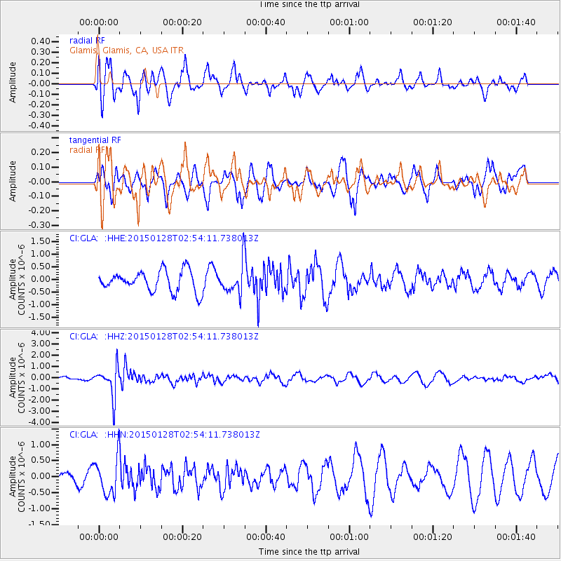
GLA Glamis, Glamis, CA, USA - Earthquake Result Viewer
*The percent match for this event was below the threshold and hence no stack was calculated.
| Earthquake location: |
Fiji Islands Region |
| Earthquake latitude/longitude: |
-20.9/-178.4 |
| Earthquake time(UTC): |
2015/01/28 (028) 02:43:19 GMT |
| Earthquake Depth: |
484 km |
| Earthquake Magnitude: |
6.1 MWP |
| Earthquake Catalog/Contributor: |
NEIC PDE/NEIC COMCAT |
|
| Network: |
CI Caltech Regional Seismic Network |
| Station: |
GLA Glamis, Glamis, CA, USA |
| Lat/Lon: |
33.05 N/114.83 W |
| Elevation: |
610 m |
|
| Distance: |
80.9 deg |
| Az: |
49.576 deg |
| Baz: |
237.938 deg |
| Ray Param: |
$rayparam |
*The percent match for this event was below the threshold and hence was not used in the summary stack. |
|
| Radial Match: |
51.549942 % |
| Radial Bump: |
400 |
| Transverse Match: |
40.66112 % |
| Transverse Bump: |
357 |
| SOD ConfigId: |
3390531 |
| Insert Time: |
2019-04-16 04:40:01.715 +0000 |
| GWidth: |
2.5 |
| Max Bumps: |
400 |
| Tol: |
0.001 |
|
Signal To Noise
| Channel | StoN | STA | LTA |
| CI:GLA: :HHZ:20150128T02:54:11.738013Z | 7.9514394 | 1.3482239E-6 | 1.6955723E-7 |
| CI:GLA: :HHN:20150128T02:54:11.738013Z | 1.9176484 | 5.891444E-7 | 3.0722234E-7 |
| CI:GLA: :HHE:20150128T02:54:11.738013Z | 1.6555165 | 6.8084137E-7 | 4.1125614E-7 |
| Arrivals |
| Ps | |
| PpPs | |
| PsPs/PpSs | |


