You are here: Home > Network List > CN - Canadian National Seismograph Network Stations List
> Station INK INUVIK, NT > Earthquake Result Viewer
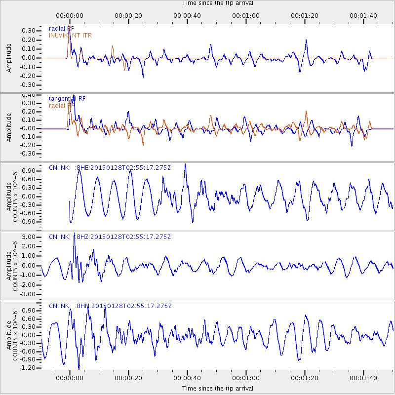
INK INUVIK, NT - Earthquake Result Viewer
*The percent match for this event was below the threshold and hence no stack was calculated.
| Earthquake location: |
Fiji Islands Region |
| Earthquake latitude/longitude: |
-20.9/-178.4 |
| Earthquake time(UTC): |
2015/01/28 (028) 02:43:19 GMT |
| Earthquake Depth: |
484 km |
| Earthquake Magnitude: |
6.1 MWP |
| Earthquake Catalog/Contributor: |
NEIC PDE/NEIC COMCAT |
|
| Network: |
CN Canadian National Seismograph Network |
| Station: |
INK INUVIK, NT |
| Lat/Lon: |
68.31 N/133.53 W |
| Elevation: |
44 m |
|
| Distance: |
94.7 deg |
| Az: |
15.248 deg |
| Baz: |
221.405 deg |
| Ray Param: |
$rayparam |
*The percent match for this event was below the threshold and hence was not used in the summary stack. |
|
| Radial Match: |
69.10387 % |
| Radial Bump: |
400 |
| Transverse Match: |
73.539566 % |
| Transverse Bump: |
400 |
| SOD ConfigId: |
3390531 |
| Insert Time: |
2019-04-16 04:40:38.294 +0000 |
| GWidth: |
2.5 |
| Max Bumps: |
400 |
| Tol: |
0.001 |
|
Signal To Noise
| Channel | StoN | STA | LTA |
| CN:INK: :BHZ:20150128T02:55:17.275Z | 2.1351955 | 1.223434E-6 | 5.7298456E-7 |
| CN:INK: :BHN:20150128T02:55:17.275Z | 1.2218251 | 6.312343E-7 | 5.1663227E-7 |
| CN:INK: :BHE:20150128T02:55:17.275Z | 0.6299247 | 3.4006788E-7 | 5.398548E-7 |
| Arrivals |
| Ps | |
| PpPs | |
| PsPs/PpSs | |


