You are here: Home > Network List > II - Global Seismograph Network (GSN - IRIS/IDA) Stations List
> Station WRAB Tennant Creek, NT, Australia > Earthquake Result Viewer
WRAB Tennant Creek, NT, Australia - Earthquake Result Viewer
*The percent match for this event was below the threshold and hence no stack was calculated.
| Earthquake location: |
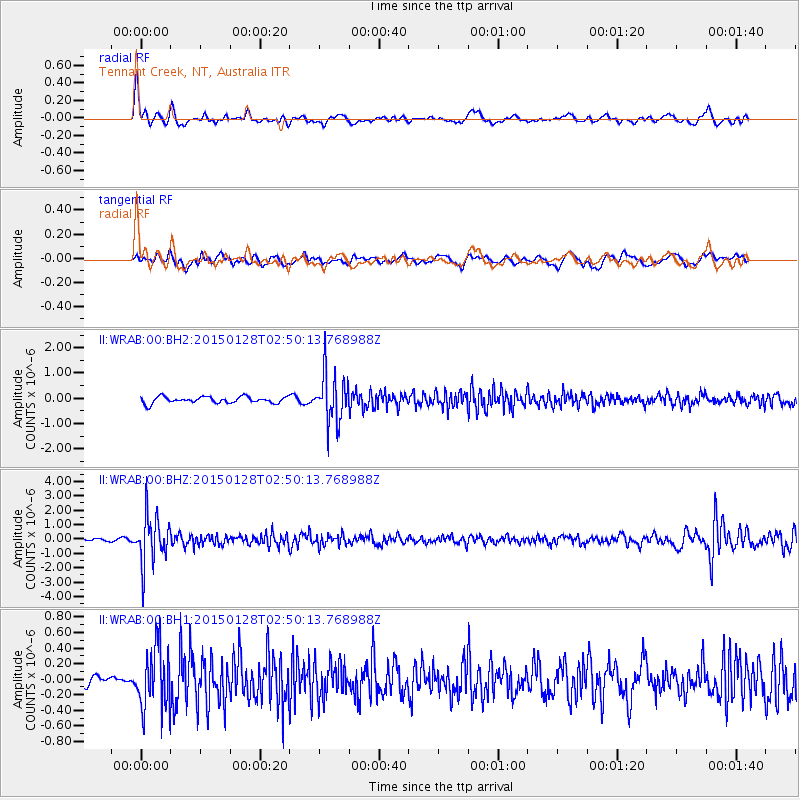
Fiji Islands Region |
| Earthquake latitude/longitude: |
-20.9/-178.4 |
| Earthquake time(UTC): |
2015/01/28 (028) 02:43:19 GMT |
| Earthquake Depth: |
484 km |
| Earthquake Magnitude: |
6.1 MWP |
| Earthquake Catalog/Contributor: |
NEIC PDE/NEIC COMCAT |
|
| Network: |
II Global Seismograph Network (GSN - IRIS/IDA) |
| Station: |
WRAB Tennant Creek, NT, Australia |
| Lat/Lon: |
19.93 S/134.36 E |
| Elevation: |
366 m |
|
| Distance: |
44.2 deg |
| Az: |
262.544 deg |
| Baz: |
99.814 deg |
| Ray Param: |
$rayparam |
*The percent match for this event was below the threshold and hence was not used in the summary stack. |
|
| Radial Match: |
75.36718 % |
| Radial Bump: |
358 |
| Transverse Match: |
48.468998 % |
| Transverse Bump: |
400 |
| SOD ConfigId: |
3390531 |
| Insert Time: |
2019-04-16 04:41:11.492 +0000 |
| GWidth: |
2.5 |
| Max Bumps: |
400 |
| Tol: |
0.001 |
|
Signal To Noise
| Channel | StoN | STA | LTA |
| II:WRAB:00:BHZ:20150128T02:50:13.768988Z | 12.251531 | 1.6754029E-6 | 1.367505E-7 |
| II:WRAB:00:BH1:20150128T02:50:13.768988Z | 5.600481 | 3.8547347E-7 | 6.882864E-8 |
| II:WRAB:00:BH2:20150128T02:50:13.768988Z | 7.4238534 | 9.73428E-7 | 1.3112165E-7 |
| Arrivals |
| Ps | |
| PpPs | |
| PsPs/PpSs | |


