You are here: Home > Network List > II - Global Seismograph Network (GSN - IRIS/IDA) Stations List
> Station WRAB Tennant Creek, NT, Australia > Earthquake Result Viewer
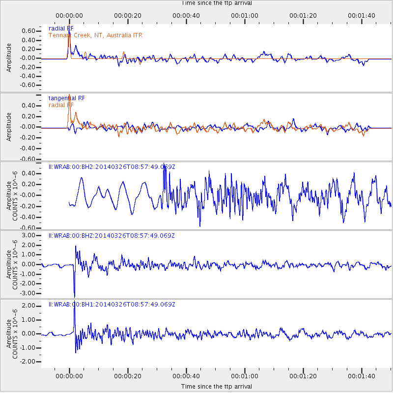
WRAB Tennant Creek, NT, Australia - Earthquake Result Viewer
*The percent match for this event was below the threshold and hence no stack was calculated.
| Earthquake location: |
Southeast Of Ryukyu Islands |
| Earthquake latitude/longitude: |
28.2/131.5 |
| Earthquake time(UTC): |
2014/03/26 (085) 08:49:41 GMT |
| Earthquake Depth: |
10 km |
| Earthquake Magnitude: |
5.6 MWP, 1.0 MI, 5.4 MWC, 5.5 MWW |
| Earthquake Catalog/Contributor: |
NEIC PDE/NEIC COMCAT |
|
| Network: |
II Global Seismograph Network (GSN - IRIS/IDA) |
| Station: |
WRAB Tennant Creek, NT, Australia |
| Lat/Lon: |
19.93 S/134.36 E |
| Elevation: |
366 m |
|
| Distance: |
47.9 deg |
| Az: |
176.338 deg |
| Baz: |
356.564 deg |
| Ray Param: |
$rayparam |
*The percent match for this event was below the threshold and hence was not used in the summary stack. |
|
| Radial Match: |
63.700848 % |
| Radial Bump: |
400 |
| Transverse Match: |
71.41002 % |
| Transverse Bump: |
400 |
| SOD ConfigId: |
626651 |
| Insert Time: |
2014-04-21 14:07:10.369 +0000 |
| GWidth: |
2.5 |
| Max Bumps: |
400 |
| Tol: |
0.001 |
|
Signal To Noise
| Channel | StoN | STA | LTA |
| II:WRAB:00:BHZ:20140326T08:57:49.069Z | 3.5504866 | 9.50107E-7 | 2.675991E-7 |
| II:WRAB:00:BH1:20140326T08:57:49.069Z | 3.8835664 | 6.650063E-7 | 1.7123598E-7 |
| II:WRAB:00:BH2:20140326T08:57:49.069Z | 1.5278275 | 2.3803051E-7 | 1.5579671E-7 |
| Arrivals |
| Ps | |
| PpPs | |
| PsPs/PpSs | |


