You are here: Home > Network List > IU - Global Seismograph Network (GSN - IRIS/USGS) Stations List
> Station CTAO Charters Towers, Australia > Earthquake Result Viewer
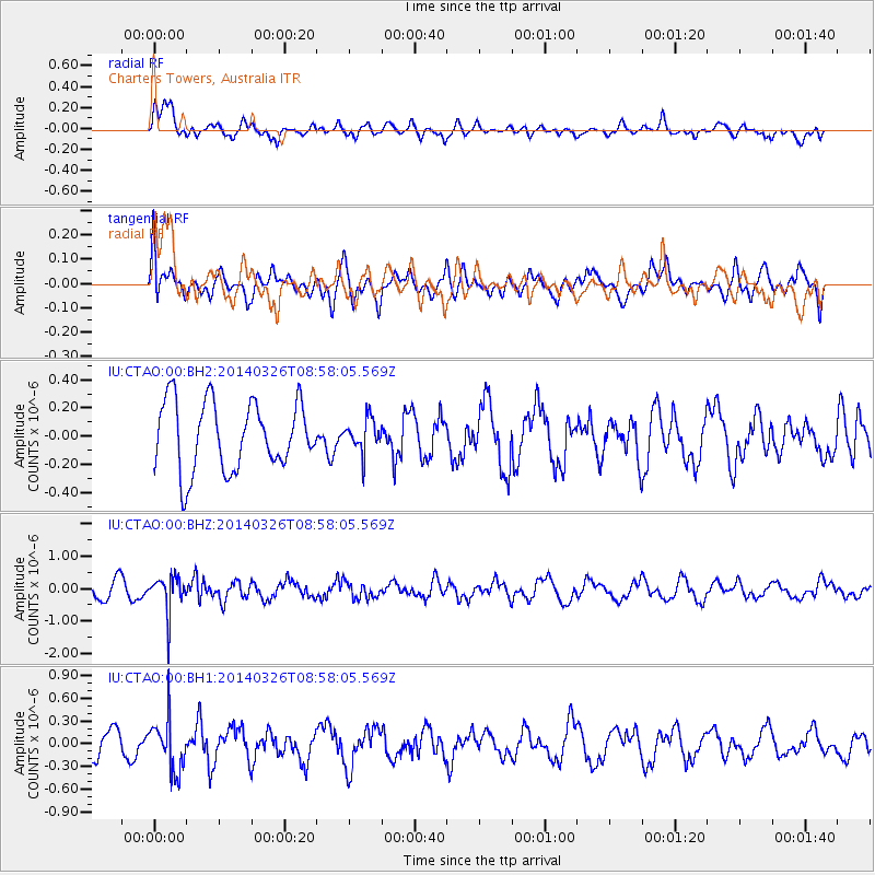
CTAO Charters Towers, Australia - Earthquake Result Viewer
*The percent match for this event was below the threshold and hence no stack was calculated.
| Earthquake location: |
Southeast Of Ryukyu Islands |
| Earthquake latitude/longitude: |
28.2/131.5 |
| Earthquake time(UTC): |
2014/03/26 (085) 08:49:41 GMT |
| Earthquake Depth: |
10 km |
| Earthquake Magnitude: |
5.6 MWP, 1.0 MI, 5.4 MWC, 5.5 MWW |
| Earthquake Catalog/Contributor: |
NEIC PDE/NEIC COMCAT |
|
| Network: |
IU Global Seismograph Network (GSN - IRIS/USGS) |
| Station: |
CTAO Charters Towers, Australia |
| Lat/Lon: |
20.09 S/146.25 E |
| Elevation: |
357 m |
|
| Distance: |
50.1 deg |
| Az: |
161.773 deg |
| Baz: |
342.914 deg |
| Ray Param: |
$rayparam |
*The percent match for this event was below the threshold and hence was not used in the summary stack. |
|
| Radial Match: |
66.938 % |
| Radial Bump: |
400 |
| Transverse Match: |
40.041424 % |
| Transverse Bump: |
400 |
| SOD ConfigId: |
626651 |
| Insert Time: |
2014-04-21 14:07:28.897 +0000 |
| GWidth: |
2.5 |
| Max Bumps: |
400 |
| Tol: |
0.001 |
|
Signal To Noise
| Channel | StoN | STA | LTA |
| IU:CTAO:00:BHZ:20140326T08:58:05.569Z | 2.6686707 | 5.5393434E-7 | 2.075694E-7 |
| IU:CTAO:00:BH1:20140326T08:58:05.569Z | 1.9913013 | 3.3889827E-7 | 1.7018935E-7 |
| IU:CTAO:00:BH2:20140326T08:58:05.569Z | 0.47161582 | 1.1363285E-7 | 2.4094368E-7 |
| Arrivals |
| Ps | |
| PpPs | |
| PsPs/PpSs | |


