You are here: Home > Network List > NX - Nanometrics Research Network Stations List
> Station STN02 Seismic station 02 > Earthquake Result Viewer
STN02 Seismic station 02 - Earthquake Result Viewer
| Earthquake location: |
Fiji Islands Region |
| Earthquake latitude/longitude: |
-20.9/-178.4 |
| Earthquake time(UTC): |
2015/01/28 (028) 02:43:19 GMT |
| Earthquake Depth: |
484 km |
| Earthquake Magnitude: |
6.1 MWP |
| Earthquake Catalog/Contributor: |
NEIC PDE/NEIC COMCAT |
|
| Network: |
NX Nanometrics Research Network |
| Station: |
STN02 Seismic station 02 |
| Lat/Lon: |
35.95 N/97.51 W |
| Elevation: |
342 m |
|
| Distance: |
95.0 deg |
| Az: |
53.522 deg |
| Baz: |
247.9 deg |
| Ray Param: |
0.040444978 |
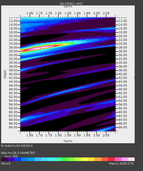
| Estimated Moho Depth: |
26.0 km |
| Estimated Crust Vp/Vs: |
1.71 |
| Assumed Crust Vp: |
6.426 km/s |
| Estimated Crust Vs: |
3.769 km/s |
| Estimated Crust Poisson's Ratio: |
0.24 |
|
| Radial Match: |
83.843414 % |
| Radial Bump: |
316 |
| Transverse Match: |
53.276882 % |
| Transverse Bump: |
356 |
| SOD ConfigId: |
3390531 |
| Insert Time: |
2019-04-16 04:41:57.476 +0000 |
| GWidth: |
2.5 |
| Max Bumps: |
400 |
| Tol: |
0.001 |
|

Signal To Noise
| Channel | StoN | STA | LTA |
| NX:STN02: :HHZ:20150128T02:55:18.13999Z | 2.0914712 | 1.749687E-6 | 8.3658193E-7 |
| NX:STN02: :HH1:20150128T02:55:18.13999Z | 1.7306124 | 2.0897019E-6 | 1.2074927E-6 |
| NX:STN02: :HH2:20150128T02:55:18.13999Z | 1.1707457 | 1.3477172E-6 | 1.1511613E-6 |
| Arrivals |
| Ps | 2.9 SECOND |
| PpPs | 11 SECOND |
| PsPs/PpSs | 14 SECOND |


