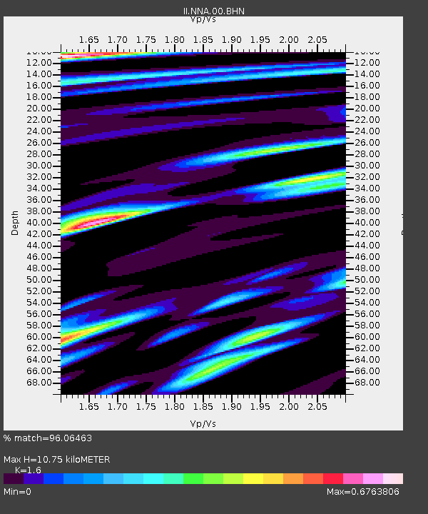
NNA Nana, Peru - Earthquake Result Viewer

Earthquake location: South Georgia Island Region
Earthquake latitude/longitude: -56.1/-36.4
Earthquake time(UTC): 2002/11/15 (319) 19:58:31 GMT
Earthquake Depth: 10 km
Earthquake Magnitude: 6.1 MB, 6.6 MS, 6.7 MW, 6.4 MW
Earthquake Catalog/Contributor: WHDF/NEIC
Network: II Global Seismograph Network (GSN - IRIS/IDA)
Station: NNA Nana, Peru
Lat/Lon: 11.99 S/76.84 W
Elevation: 575 m
Distance: 53.9 deg
Az: 308.27 deg
Baz: 153.246 deg
Ray Param: 0.06576405
Estimated Moho Depth: 10.75 km
Estimated Crust Vp/Vs: 1.60
Assumed Crust Vp: 6.472 km/s
Estimated Crust Vs: 4.045 km/s
Estimated Crust Poisson's Ratio: 0.18
Radial Match: 96.06463 %
Radial Bump: 400
Transverse Match: 90.68931 %
Transverse Bump: 400
SOD ConfigId: 4714
Insert Time: 2010-03-01 19:38:23.865 +0000
GWidth: 2.5
Max Bumps: 400
Tol: 0.001

Signal To Noise

ChannelStoNSTALTA
II:NNA:00:BHN:20021115T20:07:24.454011Z3.63494782.8000858E-77.7032354E-8
II:NNA:00:BHE:20021115T20:07:24.454011Z1.1491391.0195369E-78.87218E-8
II:NNA:00:BHZ:20021115T20:07:24.454011Z3.98693875.0063477E-71.2556872E-7
Arrivals
Ps1.1 SECOND
PpPs4.1 SECOND
PsPs/PpSs5.1 SECOND