You are here: Home > Network List > TA - USArray Transportable Network (new EarthScope stations) Stations List
> Station C06D Leavenworth, WQ, USA > Earthquake Result Viewer
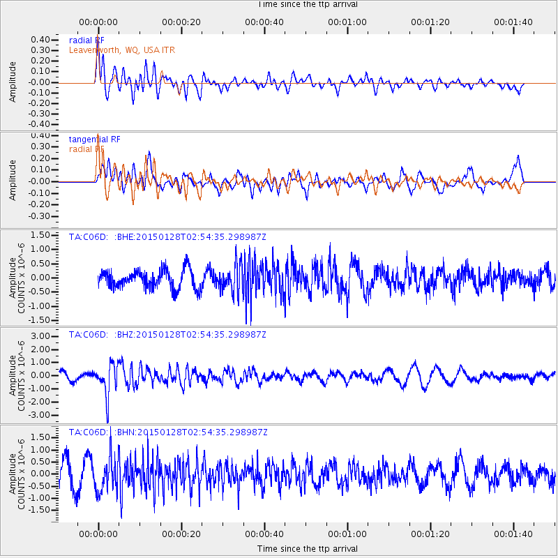
C06D Leavenworth, WQ, USA - Earthquake Result Viewer
*The percent match for this event was below the threshold and hence no stack was calculated.
| Earthquake location: |
Fiji Islands Region |
| Earthquake latitude/longitude: |
-20.9/-178.4 |
| Earthquake time(UTC): |
2015/01/28 (028) 02:43:19 GMT |
| Earthquake Depth: |
484 km |
| Earthquake Magnitude: |
6.1 MWP |
| Earthquake Catalog/Contributor: |
NEIC PDE/NEIC COMCAT |
|
| Network: |
TA USArray Transportable Network (new EarthScope stations) |
| Station: |
C06D Leavenworth, WQ, USA |
| Lat/Lon: |
47.92 N/120.89 W |
| Elevation: |
544 m |
|
| Distance: |
85.7 deg |
| Az: |
34.655 deg |
| Baz: |
232.226 deg |
| Ray Param: |
$rayparam |
*The percent match for this event was below the threshold and hence was not used in the summary stack. |
|
| Radial Match: |
48.588806 % |
| Radial Bump: |
400 |
| Transverse Match: |
48.618893 % |
| Transverse Bump: |
400 |
| SOD ConfigId: |
3390531 |
| Insert Time: |
2019-04-16 04:42:55.397 +0000 |
| GWidth: |
2.5 |
| Max Bumps: |
400 |
| Tol: |
0.001 |
|
Signal To Noise
| Channel | StoN | STA | LTA |
| TA:C06D: :BHZ:20150128T02:54:35.298987Z | 5.5150075 | 1.2234967E-6 | 2.2184861E-7 |
| TA:C06D: :BHN:20150128T02:54:35.298987Z | 1.2586614 | 7.1272893E-7 | 5.662595E-7 |
| TA:C06D: :BHE:20150128T02:54:35.298987Z | 1.563368 | 5.0427576E-7 | 3.225573E-7 |
| Arrivals |
| Ps | |
| PpPs | |
| PsPs/PpSs | |


