You are here: Home > Network List > TA - USArray Transportable Network (new EarthScope stations) Stations List
> Station G03D McMinnville, OR, USA > Earthquake Result Viewer
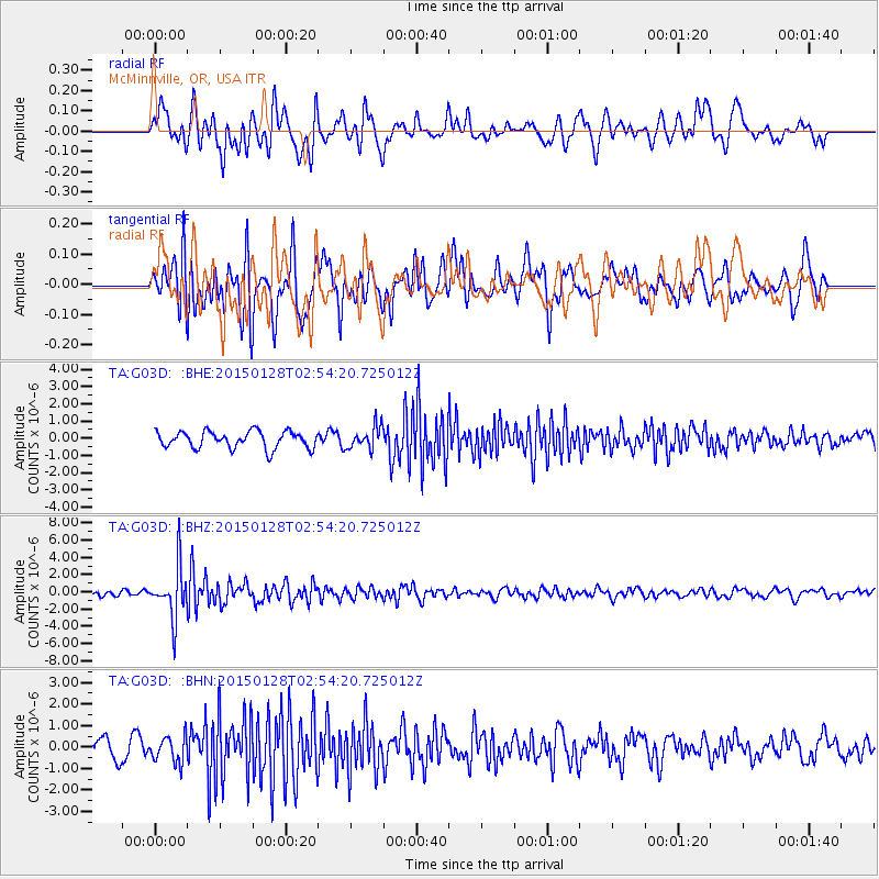
G03D McMinnville, OR, USA - Earthquake Result Viewer
*The percent match for this event was below the threshold and hence no stack was calculated.
| Earthquake location: |
Fiji Islands Region |
| Earthquake latitude/longitude: |
-20.9/-178.4 |
| Earthquake time(UTC): |
2015/01/28 (028) 02:43:19 GMT |
| Earthquake Depth: |
484 km |
| Earthquake Magnitude: |
6.1 MWP |
| Earthquake Catalog/Contributor: |
NEIC PDE/NEIC COMCAT |
|
| Network: |
TA USArray Transportable Network (new EarthScope stations) |
| Station: |
G03D McMinnville, OR, USA |
| Lat/Lon: |
45.21 N/123.26 W |
| Elevation: |
222 m |
|
| Distance: |
82.7 deg |
| Az: |
35.761 deg |
| Baz: |
230.622 deg |
| Ray Param: |
$rayparam |
*The percent match for this event was below the threshold and hence was not used in the summary stack. |
|
| Radial Match: |
60.61916 % |
| Radial Bump: |
400 |
| Transverse Match: |
68.945496 % |
| Transverse Bump: |
400 |
| SOD ConfigId: |
3390531 |
| Insert Time: |
2019-04-16 04:42:59.290 +0000 |
| GWidth: |
2.5 |
| Max Bumps: |
400 |
| Tol: |
0.001 |
|
Signal To Noise
| Channel | StoN | STA | LTA |
| TA:G03D: :BHZ:20150128T02:54:20.725012Z | 5.5466743 | 2.9561265E-6 | 5.329548E-7 |
| TA:G03D: :BHN:20150128T02:54:20.725012Z | 1.381837 | 6.000205E-7 | 4.3421946E-7 |
| TA:G03D: :BHE:20150128T02:54:20.725012Z | 1.2984508 | 6.349282E-7 | 4.8898903E-7 |
| Arrivals |
| Ps | |
| PpPs | |
| PsPs/PpSs | |


